Meulles | |
|---|---|
Part of Livarot-Pays-d'Auge | |
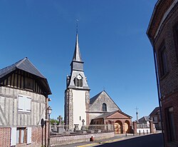 | |
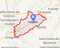 Location of Meulles | |
Meulles Meulles | |
| Coordinates: 48°58′35″N 0°19′55″E / 48.9764°N 0.3319°E / 48.9764; 0.3319 | |
| Country | France |
| Region | Normandy |
| Department | Calvados |
| Arrondissement | Lisieux |
| Canton | Livarot-Pays-d'Auge |
| Commune | Livarot-Pays-d'Auge |
Area 1 | 16.29 km2 (6.29 sq mi) |
| Population (2023)1 | 316 |
| • Density | 19.4/km2 (50.2/sq mi) |
| Time zone | UTC+01:00 (CET) |
| • Summer (DST) | UTC+02:00 (CEST) |
| Postal code | 14290 |
| Elevation | 144–228 m (472–748 ft) (avg. 216 m or 709 ft) |
| 1 French Land Register data, which excludes lakes, ponds, glaciers > 1 km2 (0.386 sq mi or 247 acres) and river estuaries. | |
Meulles (French pronunciation: [møl] ⓘ) is a former commune in the Calvados department in the Normandy region in northwestern France. On 1 January 2016, it was merged into the new commune of Livarot-Pays-d'Auge.2
Sights
- The Statue of Ada.
References
References
- "Populations de référence 2023" [Reference populations 2023] (PDF) (in French). INSEE. December 2025.
- Arrêté préfectoral 24 December 2015 (in French)