| McClellan Butte | |
|---|---|
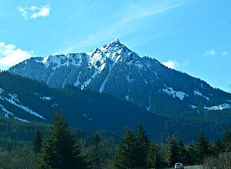 McClellan Butte from westbound Interstate 90 | |
| Highest point | |
| Elevation | 5,162 ft (1,573 m) NAVD 881 |
| Prominence | 1,442 ft (440 m)2 |
| Coordinates | 47°24′25″N 121°37′20″W / 47.406931772°N 121.622201319°W / 47.406931772; -121.6222013191 |
| Geography | |
McClellan Butte McClellan Butte (the United States) Show map of the United States | |
| Parent range | Cascade Range |
| Topo map | USGS Bandera |
| Climbing | |
| Easiest route | Maintained Hiking Trail, Short final rock scramble |
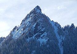
McClellan Butte is a prominent peak in the Cascade Range in King County, Washington 11 miles east of North Bend.2 The McClellan Butte hiking trail is a difficult trail known as an alternative to Mount Si's crowded trail.34
Avalanches can occur in winter months. In March 2018, two snowshoers were caught in an avalanche but both survived.5
Climate
McClellan Butte is located in the marine west coast climate zone of western North America.6 Most weather fronts originate in the Pacific Ocean, and travel northeast toward the Cascade Mountains. As fronts approach, they are forced upward by the peaks of the Cascade Range, causing them to drop their moisture in the form of rain or snowfall onto the Cascades (Orographic lift). As a result, the west side of the Cascades experiences high precipitation, especially during the winter months in the form of snowfall. During winter months, weather is usually cloudy, but, due to high pressure systems over the Pacific Ocean that intensify during summer months, there is often little or no cloud cover during the summer.7 Precipitation runoff from McClellan Butte drains into the Snoqualmie River.
References
References
- "McClellan Butte 2". NGS Data Sheet. National Geodetic Survey, National Oceanic and Atmospheric Administration, United States Department of Commerce.
- "McClellan Butte, Washington". Peakbagger.com. Retrieved February 3, 2009.
- "McClellan Butte Trail #1015". US Forest Service. Archived from the original on October 5, 2011. Retrieved January 3, 2011.
- Karen Sykes (September 24, 1998). "Spectacular vistas are the reward for tackling "McClellan Brute" trail". Seattle Post-Intelligencer.
- McCall, Danna (March 5, 2018). "Avalanches in Cascades claim five lives in one week; 'danger in many areas still high'". Living Snoqualmie. Retrieved July 28, 2025.
- Beckey, Fred W. Cascade Alpine Guide, Climbing and High Routes. Seattle, WA: Mountaineers Books, 2008.
- Beckey, p. 16
External links
External links
- "McClellan Butte". Geographic Names Information System. United States Geological Survey, United States Department of the Interior. Retrieved February 3, 2009.