| Mayon, Cornwall | |
|---|---|
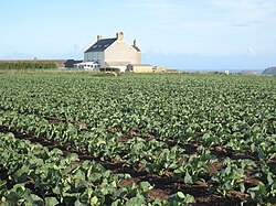 A field of young cauliflowers at Mayon Farm | |
Mayon, Cornwall Location within Cornwall | |
| OS grid reference | SW359258 |
| Unitary authority | |
| Ceremonial county | |
| Region | |
| Country | England |
| Sovereign state | United Kingdom |
| Post town | Penzance |
| Postcode district | TR19 |
Mayon is a hamlet on the A30 main road north of Sennen in west Cornwall, England.12 Mayon is about 7 miles (11 km) south-west of Penzance.1
Much of the land in St Levan belonged to the manor of Mayon, and in the early 17th century the land was divided between six heiresses, one of whom married John St Aubyn.
References
References
- Ordnance Survey: Landranger map sheet 203 Land's End & Isles of Scilly (St Ives & Lizard Point) (Map). Ordnance Survey. 2009. ISBN 978-0-319-23289-7.
- Ordnance Survey Explorer 7; Land's End, Penzance and St. Ives, 1:25 000 scale. 1996
- Mayon cliff [1]