Marquefave | |
|---|---|
 The church in Marquefave | |
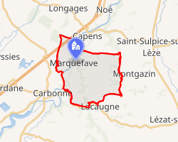 Location of Marquefave | |
Marquefave Marquefave | |
| Coordinates: 43°19′05″N 1°14′50″E / 43.3181°N 1.2472°E / 43.3181; 1.2472 | |
| Country | France |
| Region | Occitania |
| Department | Haute-Garonne |
| Arrondissement | Muret |
| Canton | Auterive |
| Intercommunality | Volvestre |
| Government | |
| • Mayor (2020–2026) | Éric Payen1 |
Area 1 | 18.92 km2 (7.31 sq mi) |
| Population (2023)2 | 991 |
| • Density | 52.4/km2 (136/sq mi) |
| Time zone | UTC+01:00 (CET) |
| • Summer (DST) | UTC+02:00 (CEST) |
| INSEE/Postal code | 31320 /31390 |
| Elevation | 175–323 m (574–1,060 ft) (avg. 207 m or 679 ft) |
| 1 French Land Register data, which excludes lakes, ponds, glaciers > 1 km2 (0.386 sq mi or 247 acres) and river estuaries. | |
Marquefave (French pronunciation: [maʁkəfav]; Occitan: Marcahava) is a commune in the Haute-Garonne department in southwestern France.
Geography
The village lies on the banks of the Garonne river.
The commune is bordered by five other communes: Capens across the river Garonne and the land border to the north, Montaut to the northwest, Montgazin to the east, Lacaugne to the south, and finally by Carbonne across the river Garonne to the west.
Population
| Year | Pop. | ±% |
|---|---|---|
| 1962 | 539 | — |
| 1968 | 570 | +5.8% |
| 1975 | 535 | −6.1% |
| 1982 | 632 | +18.1% |
| 1990 | 772 | +22.2% |
| 1999 | 850 | +10.1% |
| 2008 | 1,012 | +19.1% |
References
References
- "Répertoire national des élus: les maires" (in French). data.gouv.fr, Plateforme ouverte des données publiques françaises. 13 September 2022.
- "Populations de référence 2023" (in French). National Institute of Statistics and Economic Studies. 18 December 2025.