Margival | |
|---|---|
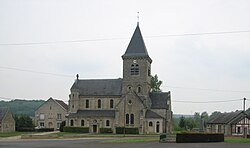 The church of Margival | |
 Coat of arms | |
 Location of Margival | |
Margival Margival | |
| Coordinates: 49°26′07″N 3°24′09″E / 49.4353°N 3.4025°E / 49.4353; 3.4025 | |
| Country | France |
| Region | Hauts-de-France |
| Department | Aisne |
| Arrondissement | Soissons |
| Canton | Fère-en-Tardenois |
| Intercommunality | Val de l'Aisne |
| Government | |
| • Mayor (2024–2026) | Jean-Pierre Poletz1 |
Area 1 | 5.47 km2 (2.11 sq mi) |
| Population (2023)2 | 377 |
| • Density | 68.9/km2 (179/sq mi) |
| Time zone | UTC+01:00 (CET) |
| • Summer (DST) | UTC+02:00 (CEST) |
| INSEE/Postal code | 02464 /02880 |
| Elevation | 66–164 m (217–538 ft) (avg. 81 m or 266 ft) |
| 1 French Land Register data, which excludes lakes, ponds, glaciers > 1 km2 (0.386 sq mi or 247 acres) and river estuaries. | |
Margival (French pronunciation: [maʁʒival]) is a commune in the Aisne department in Hauts-de-France in northern France.
It is located 10 kilometres (6.2 mi) northeast of Soissons.
History
During World War II, the Führerhauptquartier Wolfsschlucht II, one of the Adolf Hitler's Western Front military headquarters, was built there.
Population
| Year | Pop. | ±% p.a. |
|---|---|---|
| 1968 | 258 | — |
| 1975 | 264 | +0.33% |
| 1982 | 321 | +2.83% |
| 1990 | 321 | +0.00% |
| 1999 | 325 | +0.14% |
| 2007 | 323 | −0.08% |
| 2012 | 353 | +1.79% |
| 2017 | 370 | +0.95% |
| 2023 | 377 | +0.31% |
| Source: INSEE3 | ||
References
References
- "Répertoire national des élus: les maires" (in French). data.gouv.fr, Plateforme ouverte des données publiques françaises. 12 March 2025.
- "Populations de référence 2023" (in French). National Institute of Statistics and Economic Studies. 18 December 2025.
- Population municipale entre 1968 et 2023, INSEE