Maing | |
|---|---|
 The town hall in Maing | |
 Coat of arms | |
 Location of Maing | |
Maing Maing | |
| Coordinates: 50°18′32″N 3°29′10″E / 50.309°N 3.486°E / 50.309; 3.486 | |
| Country | France |
| Region | Hauts-de-France |
| Department | Nord |
| Arrondissement | Valenciennes |
| Canton | Aulnoy-lez-Valenciennes |
| Intercommunality | CA Valenciennes Métropole |
| Government | |
| • Mayor (2020–2026) | Philippe Baudrin1 |
Area 1 | 11.68 km2 (4.51 sq mi) |
| Population (2023)2 | 3,954 |
| • Density | 338.5/km2 (876.8/sq mi) |
| Time zone | UTC+01:00 (CET) |
| • Summer (DST) | UTC+02:00 (CEST) |
| INSEE/Postal code | 59369 /59233 |
| Elevation | 24–90 m (79–295 ft) (avg. 80 m or 260 ft) |
| 1 French Land Register data, which excludes lakes, ponds, glaciers > 1 km2 (0.386 sq mi or 247 acres) and river estuaries. | |
Maing (French pronunciation: [mɛ̃]) is a commune in the Nord department, northern France.3
Fontenelle Abbey was located here.
Population
| Year | Pop. | ±% p.a. |
|---|---|---|
| 1968 | 4,244 | — |
| 1975 | 4,483 | +0.79% |
| 1982 | 4,445 | −0.12% |
| 1990 | 4,183 | −0.76% |
| 1999 | 3,845 | −0.93% |
| 2007 | 3,944 | +0.32% |
| 2012 | 4,047 | +0.52% |
| 2017 | 4,112 | +0.32% |
| 2023 | 3,954 | −0.65% |
| Source: INSEE4 | ||
Heraldry
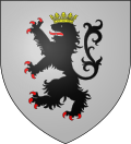 |
The arms of Maing are blazoned : Argent, a lion sable, crowned Or, armed and langued gules. (The arms of Bambecque, Killem and Maing are essentially the same)
|
References
References
- "Répertoire national des élus: les maires". data.gouv.fr, Plateforme ouverte des données publiques françaises (in French). 2 December 2020.
- "Populations de référence 2023" (in French). National Institute of Statistics and Economic Studies. 18 December 2025.
- INSEE commune file
- Population municipale entre 1968 et 2023, INSEE