| Macho | |
|---|---|
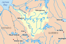 Watershed of Nottaway River | |
| Location | |
| Country | Canada |
| Province | Quebec |
| Region | Nord-du-Québec |
| Physical characteristics | |
| Source | |
| • location | Senneterre, La Vallée-de-l'Or Regional County Municipality (RCM), Abitibi-Témiscamingue, Quebec |
| • coordinates | 49°03′37″N 75°44′40″W / 49.06028°N 75.74444°W / 49.06028; -75.74444 |
| • elevation | 390 m (1,280 ft) |
| Mouth | Berthelot River (Mégiscane River), Mégiscane River |
• location | Senneterre, Abitibi-Témiscamingue, Quebec |
• coordinates | 48°34′36″N 76°06′50″W / 48.57667°N 76.11389°W / 48.57667; -76.11389 |
• elevation | 385 m (1,263 ft) |
| Length | 69.6 km (43.2 mi)1 |
| Basin features | |
| Tributaries | |
| • left |
|
| • right |
|
The Macho River is a tributary of the Mégiscane River, flowing in Quebec, Canada, in the territories of:
- Eeyou Istchee James Bay (Municipality), in the administrative region of Nord-du-Québec;
- Senneterre, in La Vallée-de-l'Or Regional County Municipality, in the administrative region of Abitibi-Témiscamingue, where the course of the river crosses successively the cantons of Souart, Masères, Closse, Maricourt and Berthelot.
The Macho River flows entirely in forested territory north-east of the La Vérendrye Wildlife Reserve and on the west side of Gouin Reservoir. Forestry is the main economic activity of this hydrographic slope; recreational tourism activities, second.
The surface of the river is usually frozen from mid-December to mid-April. The course of this river has a difference in height of only five meters.
Geography
This source of the river is located at:
- 0.9 kilometres (0.56 mi) south-east of route 105B going up to the northeast [Panache River];
- 60.8 kilometres (37.8 mi) north of the confluence of the Macho River with Berthelot Lake (Mégiscane River);
- 132.8 kilometres (82.5 mi) north-east of downtown Senneterre;
- 73.7 kilometres (45.8 mi) northwest of the village center of Obedjiwan;
- 93.0 kilometres (57.8 mi) north of the Canadian National Railway.
The main hydrographic slopes near the Macho River are:
- North side: Panache River, Fortier River;
- east side: Barry Lake (Saint-Cyr River South), Saint-Cyr River South, Saint-Cyr Lake (Saint-Cyr River South), Mégiscane Lake, Mégiscane River;
- South side: Mégiscane River, Berthelot lake;
- West side: Wetetnagami River, Saint-Père River, Wetetnagami Lake, Achepabanca River, Achepabanca River Northeast.
From its source, the Macho River flows over 69.6 kilometres (43.2 mi) according to the following segments:
Upper Macho River (segment of 46.7 kilometres (29.0 mi))
- 9.8 kilometres (6.1 mi) to the south surrounded by marsh areas, and enters the administrative region of Abitibi-Témiscamingue, to the north shore of Loutres Lake;
- 7.7 kilometres (4.8 mi) southerly crossing Loutres Lake (elevation: 387 metres (1,270 ft)) to its mouth on the west shore;
- 10.9 kilometres (6.8 mi) southwesterly through marsh areas on each side of the river to the north shore of Maseres Lake;
- 18.3 kilometres (11.4 mi) southerly, crossing Maseres Lake (elevation: 385 metres (1,263 ft)) to its mouth;
Lower Macho River (segment of 26.0 kilometres (16.2 mi))
- 5.6 kilometres (3.5 mi) southerly, including crossing the unidentified lake (elevation: 385 metres (1,263 ft)) consisting of a widening of the river to its mouth;
- 7.2 kilometres (4.5 mi) southwesterly, then south, to the north shore of Maricourt Lake (Macho River);
- 6.9 kilometres (4.3 mi) southerly crossing the northern portion of Maricourt Lake (Macho River) (elevation: 385 metres (1,263 ft)) along its entire length, to a straight line formed by the reconciliation of two opposite peninsulas. Note: The Closse River (coming from the East) flows on the east shore of the northern part of this lake;
- 6.3 kilometres (3.9 mi) southerly, crossing the southern portion of Maricourt Lake (Macho River), to the confluence of the river.2
The Macho River discharges at the bottom of a bay on the north shore of Berthelot Lake (elevation: 385 metres (1,263 ft) which empties onto the north shore of the Mégiscane River The latter is a tributary of Parent Lake (Abitibi) .This latter lake empties into the Bell River, a tributary of Matagami Lake. in turn flows into the Nottaway River, a tributary of the southeast shore of James Bay.
This confluence of the Macho River with Berthelot Lake (Mégiscane River) is located opposite the confluence of the Berthelot River (Mégiscane River); upstream of Rapides Manidioc and the confluence of the Achepabanca River; and downstream of the confluence of the Whitegoose River. Specifically, the Macho River flows to:
- 62.5 kilometres (38.8 mi) East of the confluence of the Mégiscane River with Parent Lake (Abitibi);
- 36.1 kilometres (22.4 mi) north of the former Gagnon-Siding Railway Station of the Canadian National Railway;
- 86.8 kilometres (53.9 mi) north-east of the village center of Senneterre;
- 51.0 kilometres (31.7 mi) west of Gouin Reservoir.
Toponymy
The toponym "Macho River" was formalized on December 5, 1968, at the Commission de toponymie du Québec.3
See also
See also
- Nottaway River, a watercourse
- Matagami Lake, a body of water
- Bell River, a watercourse
- Parent Lake (Abitibi), a body of water
- Mégiscane River, a watercourse
- Gouin Reservoir, a body of water
- Maricourt Lake (Macho River), a body of water
- Berthelot Lake (Mégiscane River), a body of water
- Senneterre, a city
- La Vallée-de-l'Or Regional County Municipality (MRC)
- List of rivers of Quebec
References
References
- "Atlas of Canada". atlas.nrcan.gc.ca. Archived from the original on 2008-10-14. Retrieved 2018-01-25.
- River segments measured from the Atlas of Canada (published on Internet) from the Department of Natural Resources Canada
- Commission de toponymie du Quebec - Bank of Place Names - Toponym: "Macho River"