Müglitztal | |
|---|---|
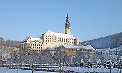 | |
 Coat of arms | |
Location of Müglitztal
within Sächsische Schweiz-Osterzgebirge district | |
 Location of Müglitztal | |
Müglitztal Müglitztal | |
| Coordinates: 50°55′N 13°49′E / 50.917°N 13.817°E / 50.917; 13.817 | |
| Country | Germany |
| State | Saxony |
| District | Sächsische Schweiz-Osterzgebirge |
| Municipal assoc. | Dohna-Müglitztal |
| Subdivisions | 7 |
| Government | |
| • Mayor (2018–25) | Michael Neumann1 |
| Area | |
• Total | 21.00 km2 (8.11 sq mi) |
| Highest elevation | 450 m (1,480 ft) |
| Lowest elevation | 150 m (490 ft) |
| Population (2024-12-31)2 | |
• Total | 1,900 |
| • Density | 90/km2 (230/sq mi) |
| Time zone | UTC+01:00 (CET) |
| • Summer (DST) | UTC+02:00 (CEST) |
| Postal codes | 01809 |
| Dialling codes | 035027 |
| Vehicle registration | PIR |
| Website | www.oberelbe.de |

Müglitztal is a municipality in the Sächsische Schweiz-Osterzgebirge district, in Saxony, Germany.
References
References
- Bürgermeisterwahlen 2018, Freistaat Sachsen, accessed 10 July 2021.
- "Bevölkerung der Gemeinden Sachsens am 31. Dezember 2024 – Fortschreibung des Bevölkerungsstandes auf Basis des Zensus vom 15. Mai 2022 (Gebietsstand 01.01.2024)" (in German). Statistisches Landesamt des Freistaates Sachsen.