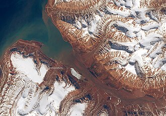
The Longyear Valley123 (Norwegian: Longyeardalen) is a valley and ravine in Svalbard. It slightly winds 40 kilometres (25 mi) WNW ending in Adventfjorden, facing west, the broadest inlet of Spitsbergen, the main landmass. It has a few wind gaps to the south and north-east over small glaciers, under which small streams form. It is between mountains Platåberget and Gruvefjellet. The town of Longyearbyen is at its foot, which is named for the American industrialist John Munro Longyear. The Longyear River is, like all the island's rivers, silted from surrounding glaciers.4
References
References
- Capelotti, P. J. 2000. The Svalbard Archipelago: American Military and Political Geographies of Spitsbergen and Other Norwegian Polar Territories, 1941–1950. Jefferson, NC: McFarland & Company, p. 32.
- Remmert, Hermann. 1980. Arctic Animal Ecology. Berlin: Springer, p. 16.
- DePasqual, Seth. 2012. Winning Coal at 78° North: Mining, Contingency and the Chaîne Opératoire in Old Longyear City. In: Louwrens Hacquebord (ed.), Lashipa: History of Large Scale Resource Exploitation in Polar Areras, pp. 71–82. Groningen: University of Groningen, p. 75.
- "Longyeardalen". Norwegian Polar Institute. Retrieved 7 April 2012.
{{cite web}}: CS1 maint: deprecated archival service (link)
78°12.5′N 15°36.4′E / 78.2083°N 15.6067°E / 78.2083; 15.6067