Lhee | |
|---|---|
Hamlet | |
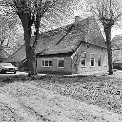 Farm in Lhee | |
 The village (dark red) and the statistical district (light green) of Lhee in the municipality of Westerveld. | |
Lhee Location in the Netherlands Show map of DrentheLhee Lhee (Netherlands) Show map of Netherlands | |
| Coordinates: 52°49′42″N 6°23′37″E / 52.82833°N 6.39361°E / 52.82833; 6.39361 | |
| Country | Netherlands |
| Province | Drenthe |
| Municipality | Westerveld |
| Area | |
• Total | 29.99 km2 (11.58 sq mi) |
| Elevation | 10 m (33 ft) |
| Population (2021)1 | |
• Total | 385 |
| • Density | 12.8/km2 (33.2/sq mi) |
| Time zone | UTC+1 (CET) |
| • Summer (DST) | UTC+2 (CEST) |
| Postal code | 79911 |
| Dialing code | 0521 |
Lhee is a hamlet in the Dutch province of Drenthe. It is a part of the municipality of Westerveld, and lies about 13 kilometres (8.1 mi) north of Hoogeveen.
The hamlet was first mentioned in 1181 as "In Lede". The etymology is unclear.3
Around 1800, a little school was built in Lhee. In 1953, it was moved brick by brick to the Netherlands Open Air Museum despite protests from the former teacher.4 Lhee was home to 229 people in 1840.4
References
References
- "Kerncijfers wijken en buurten 2021". Central Bureau of Statistics. Retrieved 12 April 2022.
two entries
- "Postcodetool for 7991AA". Actueel Hoogtebestand Nederland (in Dutch). Het Waterschapshuis. Archived from the original on 21 September 2013. Retrieved 12 April 2022.
- "Lhee - (geografische naam)". Etymologiebank (in Dutch). Retrieved 12 April 2022.
- "Lhee". Plaatsengids (in Dutch). Retrieved 12 April 2022.