Lapugnoy | |
|---|---|
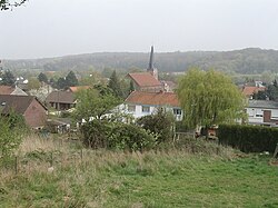 A general view of Lapugnoy | |
 Coat of arms | |
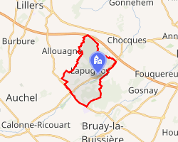 Location of Lapugnoy | |
Lapugnoy Lapugnoy | |
| Coordinates: 50°31′02″N 2°32′28″E / 50.5172°N 2.5411°E / 50.5172; 2.5411 | |
| Country | France |
| Region | Hauts-de-France |
| Department | Pas-de-Calais |
| Arrondissement | Béthune |
| Canton | Béthune |
| Intercommunality | CA Béthune-Bruay, Artois-Lys Romane |
| Government | |
| • Mayor (2020–2026) | Alain Delannoy1 |
Area 1 | 8.61 km2 (3.32 sq mi) |
| Population (2023)2 | 3,481 |
| • Density | 404/km2 (1,050/sq mi) |
| Time zone | UTC+01:00 (CET) |
| • Summer (DST) | UTC+02:00 (CEST) |
| INSEE/Postal code | 62489 /62122 |
| Elevation | 24–93 m (79–305 ft) (avg. 37 m or 121 ft) |
| 1 French Land Register data, which excludes lakes, ponds, glaciers > 1 km2 (0.386 sq mi or 247 acres) and river estuaries. | |
Lapugnoy (French pronunciation: [lapyɲwa]) is a commune in the Pas-de-Calais department in the Hauts-de-France region of France.3
Geography
A small farming and forestry town, situated some 5 miles (8.0 km) west of Béthune and 33 miles (53 km) southwest of Lille, on the D70 road, by the banks of the Clarence and traversed by the A26 autoroute..
Population
| Year | Pop. | ±% p.a. |
|---|---|---|
| 1968 | 2,645 | — |
| 1975 | 3,259 | +3.03% |
| 1982 | 3,375 | +0.50% |
| 1990 | 3,426 | +0.19% |
| 1999 | 3,310 | −0.38% |
| 2007 | 3,289 | −0.08% |
| 2012 | 3,379 | +0.54% |
| 2017 | 3,459 | +0.47% |
| 2023 | 3,481 | +0.11% |
| Source: INSEE4 | ||
Places of interest
- The Commonwealth War Graves Commission cemetery.
- The church of St. Vaast, dating from the nineteenth century.
References
References
- "Répertoire national des élus: les maires". data.gouv.fr, Plateforme ouverte des données publiques françaises (in French). 2 December 2020.
- "Populations de référence 2023" (in French). National Institute of Statistics and Economic Studies. 18 December 2025.
- INSEE commune file
- Population municipale entre 1968 et 2023, INSEE