Lalling | |
|---|---|
 Lalling | |
 Coat of arms | |
Location of Lalling
within Deggendorf district | |
 Location of Lalling | |
Lalling Lalling | |
| Coordinates: 48°51′N 13°8′E / 48.850°N 13.133°E / 48.850; 13.133 | |
| Country | Germany |
| State | Bavaria |
| Admin. region | Niederbayern |
| District | Deggendorf |
| Municipal assoc. | Lalling |
| Government | |
| • Mayor (2020–26) | Michael Reitberger1 (CSU) |
| Area | |
• Total | 27.92 km2 (10.78 sq mi) |
| Elevation | 446 m (1,463 ft) |
| Population (2024-12-31)2 | |
• Total | 1,651 |
| • Density | 59.13/km2 (153.2/sq mi) |
| Time zone | UTC+01:00 (CET) |
| • Summer (DST) | UTC+02:00 (CEST) |
| Postal codes | 94551 |
| Dialling codes | 09904 |
| Vehicle registration | DEG |
| Website | www.lalling.de |

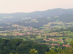
Lalling (German pronunciation: [ˈlalɪŋ]) is a municipality in the Lower Bavarian district of Deggendorf in Germany. It is a nationally recognized resort town.
Geography
Lalling is located along the Danube in the south of the Bavarian Forest, specifically in what is called the Lallinger angle.
History
Lalling and its community were first mentioned in a letter of protection from Pope Eugene III in 1148. From the early 13th Century until 1803 the Niederaltaich Abbey was its largest landlord. Lalling was considered part of the lands held by the Electorate of Bavaria. In the course of administrative reform in Bavaria, it became municipality in 1818.
Attractions
- the Tithe barn at Niederalteich Abbey
References
References
- Liste der ersten Bürgermeister/Oberbürgermeister in kreisangehörigen Gemeinden, Bayerisches Landesamt für Statistik, 15 July 2021.
- "Gemeinden, Kreise und Regierungsbezirke in Bayern, Einwohnerzahlen am 31. Dezember 2024; Basis Zensus 2022" [Municipalities, counties, and administrative districts in Bavaria; Based on the 2022 Census] (CSV) (in German). Bayerisches Landesamt für Statistik.