| Ladik Lake | |
|---|---|
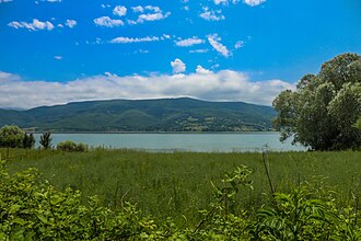 Ladik Lake | |
Ladik Lake Location within Turkey | |
| Location | Ladik District, Samsun Province, Turkey |
| Coordinates | 40°54′N 36°00′E / 40.900°N 36.000°E / 40.900; 36.000 |
| Type | Tectonic lake |
| Tersakan Çayı | |
| none | |
| Basin countries | Turkey |
| Max. length | 7 km (4.3 mi) |
| Max. width | 2 km (1.2 mi) |
Surface area | 8.7 km2 (3 sq mi) |
Average depth | 6 m (20 ft) |
| Max. depth | 13 m (43 ft) |
Shore length1 | 15 km (9.3 mi) |
Surface elevation | 950 m (3,120 ft) |
| 1 Shore length is not a well-defined measure. | |
Ladik Lake (Turkish: Ladik Gölü; Ancient Greek: Στιφάνη Λίμνη, romanized: Stiphane Limne) is a lake in Samsun Province, Asiatic Turkey. In Classical antiquity, it was called Stiphane, and is located in the northwestern part of ancient Pontus, in the area called Phazemonitis.1 According to Strabo, the lake abounded in fish, and its shores afforded excellent pasture.1 The southern shore of Ladik Lake was the epicenter of the 7.8–8.0 Ms 1668 North Anatolia earthquake, which is thought to be the most powerful earthquake in Turkey.2
References
References
This article incorporates text from a publication now in the public domain: Smith, William, ed. (1854–1857). "Stiphane". Dictionary of Greek and Roman Geography. London: John Murray.
- Strabo. Geographica. Vol. xii. p. 560. Page numbers refer to those of Isaac Casaubon's edition.
- "Tarihsel Depremler (Historical Earthquakes)". Boğaziçi University, Kandilli Observatory and Earthquake Research Institute (in Turkish). Retrieved 1 February 2020.
External links
External links