La Mitis | |
|---|---|
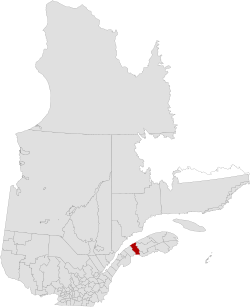 | |
| Coordinates: 48°05′N 68°01′W / 48.08°N 68.02°W / 48.08; -68.021 | |
| Country |  Canada Canada |
| Province |  Quebec Quebec |
| Region | Bas-Saint-Laurent |
| Effective | January 1, 1982 |
| County seat | Mont-Joli |
| Government | |
| • Type | Prefecture |
| • Prefect | Michel Côté |
| Area | |
• Total | 2,538.80 km2 (980.24 sq mi) |
| • Land | 2,281.25 km2 (880.80 sq mi) |
| Population (2016)3 | |
• Total | 18,210 |
| • Density | 8/km2 (21/sq mi) |
| • Change 2011–2016 |  3.9% 3.9% |
| • Dwellings | 9,692 |
| Time zone | UTC−5 (EST) |
| • Summer (DST) | UTC−4 (EDT) |
| Area codes | 418 and 581 |
| Website | www |
La Mitis is a regional county municipality in the Bas-Saint-Laurent region in eastern Quebec, Canada on the Gaspé peninsula. It is named for the Mitis River (The Mitis) which has its source in the region (at Lac Inférieur) and flows through the central part of the region before emptying into the Saint Lawrence River.
The county seat is in Mont-Joli.
Subdivisions
There are 18 subdivisions within the RCM:2
|
|
|
|
|
Demographics
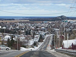
Population
Canada census – La Mitis community profile
| 2021 | 2016 | 2011 | |
|---|---|---|---|
| Population | 18,363 (+0.8% from 2016) | 18,210 (-3.9% from 2011) | 18,942 (-2.2% from 2006) |
| Land area | 2,275.56 km2 (878.60 sq mi) | 2,281.25 km2 (880.80 sq mi) | 2,279.22 km2 (880.01 sq mi) |
| Population density | 8.1/km2 (21/sq mi) | 8.0/km2 (21/sq mi) | 8.3/km2 (21/sq mi) |
| Median age | 50.8 (M: 50.0, F: 51.2) | 49.5 (M: 49.0, F: 50.1) | 48.0 (M: 47.3, F: 48.6) |
| Private dwellings | 9,842 (total) 8,492 (occupied) | 9,692 (total) | 9,471 (total) |
| Median household income | $57,600 | $48,996 | $42,351 |
Historical Census Data – La Mitis Regional County Municipality, Quebec | |||||||||||||||||||||||||
|
| ||||||||||||||||||||||||
| 73 | |||||||||||||||||||||||||
Language
| Canada Census Mother Tongue – La Mitis Regional County Municipality, Quebec73 | ||||||||||||||||||
|---|---|---|---|---|---|---|---|---|---|---|---|---|---|---|---|---|---|---|
| Census | Total | French
|
English
|
French & English
|
Other
| |||||||||||||
| Year | Responses | Count | Trend | Pop % | Count | Trend | Pop % | Count | Trend | Pop % | Count | Trend | Pop % | |||||
2016
|
17,920
|
17,665 | 2.9%
|
98.58% | 140 |  7.7% 7.7%
|
0.78% | 65 |  0.0% 0.0%
|
0.36% | 50 | 0.0%
|
0.28% | |||||
2011
|
18,430
|
18,185 | 1.6%
|
98.67% | 130 | 25.7%
|
0.71% | 65 | 44.4%
|
0.35% | 50 | 58.3%
|
0.27% | |||||
2006
|
18,815
|
18,475 | 0.05%
|
98.19% | 175 | 25.0%
|
0.93% | 45 | 18.2%
|
0.24% | 120 | 480.0%
|
0.64% | |||||
2001
|
18,705
|
18,485 | 4.4%
|
98.82% | 140 | 3.7%
|
0.75% | 55 | 15.4%
|
0.29% | 25 | 44.4%
|
0.13% | |||||
1996
|
19,580
|
19,335 | n/a | 98.75% | 135 | n/a | 0.69% | 65 | n/a | 0.33% | 45 | n/a | 0.23% | |||||
Transportation

Access routes
Highways and numbered routes that run through the municipality, including external routes that start or finish at the county border:8


See also
See also
References
References
- "Banque de noms de lieux du Québec: Reference number 141090". toponymie.gouv.qc.ca (in French). Commission de toponymie du Québec.
- "Répertoire des municipalités: Geographic code 090". www.quebec.ca (in French). Gouvernement du Québec.
- "Census Profile, 2016 Census: La Mitis, Municipalité régionale de comté [Census division], Quebec". Statistics Canada. Retrieved December 18, 2019.
- "2021 Community Profiles". 2021 Canadian census. Statistics Canada. February 4, 2022. Retrieved 2023-10-19.
- "2016 Community Profiles". 2016 Canadian census. Statistics Canada. August 12, 2021. Retrieved 2019-12-18.
- "2011 Community Profiles". 2011 Canadian census. Statistics Canada. March 21, 2019. Retrieved 2014-01-27.
- Statistics Canada: 1996, 2001, 2006, 2011 census
- Official Transport Quebec Road Map
External links
External links
Media related to La Mitis Regional County Municipality at Wikimedia Commons