La Chamba | |
|---|---|
 | |
 Coat of arms | |
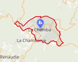 Location of La Chamba | |
La Chamba La Chamba | |
| Coordinates: 45°45′22″N 3°45′30″E / 45.7561°N 3.7583°E / 45.7561; 3.7583 | |
| Country | France |
| Region | Auvergne-Rhône-Alpes |
| Department | Loire |
| Arrondissement | Montbrison |
| Canton | Boën-sur-Lignon |
| Intercommunality | CA Loire Forez |
| Government | |
| • Mayor (2020–2026) | Valerie Halvick1 |
Area 1 | 5.2 km2 (2.0 sq mi) |
| Population (2023)2 | 42 |
| • Density | 8.1/km2 (21/sq mi) |
| Time zone | UTC+01:00 (CET) |
| • Summer (DST) | UTC+02:00 (CEST) |
| INSEE/Postal code | 42040 /42440 |
| Elevation | 983–1,344 m (3,225–4,409 ft) (avg. 1,087 m or 3,566 ft) |
| 1 French Land Register data, which excludes lakes, ponds, glaciers > 1 km2 (0.386 sq mi or 247 acres) and river estuaries. | |
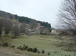
La Chamba (French pronunciation: [la ʃɑ̃ba]; Occitan: La Chambaa) is a commune in the Loire department in central France.
Climate
| Climate data for La Chamba (Col de la Loge), 1261m (1991−2020 normals, 1997−2024 extremes) | |||||||||||||
|---|---|---|---|---|---|---|---|---|---|---|---|---|---|
| Month | Jan | Feb | Mar | Apr | May | Jun | Jul | Aug | Sep | Oct | Nov | Dec | Year |
| Record high °C (°F) | 18.5 (65.3) |
19.4 (66.9) |
21.2 (70.2) |
23.7 (74.7) |
26.1 (79.0) |
32.6 (90.7) |
31.8 (89.2) |
32.9 (91.2) |
28.0 (82.4) |
25.6 (78.1) |
21.4 (70.5) |
16.5 (61.7) |
32.9 (91.2) |
| Mean daily maximum °C (°F) | 2.6 (36.7) |
3.1 (37.6) |
6.4 (43.5) |
9.8 (49.6) |
13.7 (56.7) |
18.0 (64.4) |
19.8 (67.6) |
19.9 (67.8) |
15.9 (60.6) |
11.8 (53.2) |
6.0 (42.8) |
3.6 (38.5) |
10.9 (51.6) |
| Daily mean °C (°F) | −0.2 (31.6) |
0.0 (32.0) |
2.9 (37.2) |
5.8 (42.4) |
9.5 (49.1) |
13.5 (56.3) |
15.2 (59.4) |
15.4 (59.7) |
11.9 (53.4) |
8.5 (47.3) |
3.3 (37.9) |
0.9 (33.6) |
7.2 (45.0) |
| Mean daily minimum °C (°F) | −3.0 (26.6) |
−3.1 (26.4) |
−0.6 (30.9) |
1.8 (35.2) |
5.4 (41.7) |
9.1 (48.4) |
10.6 (51.1) |
11.0 (51.8) |
8.0 (46.4) |
5.1 (41.2) |
0.5 (32.9) |
−1.9 (28.6) |
3.6 (38.4) |
| Record low °C (°F) | −15.3 (4.5) |
−19.1 (−2.4) |
−16.5 (2.3) |
−8.9 (16.0) |
−4.4 (24.1) |
−0.9 (30.4) |
2.5 (36.5) |
1.8 (35.2) |
−1.0 (30.2) |
−9.9 (14.2) |
−14.1 (6.6) |
−17.3 (0.9) |
−19.1 (−2.4) |
| Average precipitation mm (inches) | 100.9 (3.97) |
85.6 (3.37) |
92.0 (3.62) |
95.5 (3.76) |
123.6 (4.87) |
102.2 (4.02) |
107.4 (4.23) |
116.0 (4.57) |
91.7 (3.61) |
112.9 (4.44) |
126.4 (4.98) |
119.2 (4.69) |
1,273.4 (50.13) |
| Average precipitation days | 13.6 | 12.5 | 12.5 | 12.7 | 13.4 | 10.8 | 11.3 | 10.7 | 9.6 | 12.0 | 13.9 | 14.6 | 147.7 |
| Source: Meteociel3 | |||||||||||||
Population
| Year | Pop. | ±% p.a. |
|---|---|---|
| 1968 | 87 | — |
| 1975 | 81 | −1.02% |
| 1982 | 68 | −2.47% |
| 1990 | 56 | −2.40% |
| 1999 | 53 | −0.61% |
| 2007 | 57 | +0.91% |
| 2012 | 51 | −2.20% |
| 2017 | 50 | −0.40% |
| 2023 | 42 | −2.86% |
| Source: INSEE4 | ||
Heraldry
|
Azure, a mount of Tenné charged, on the dexter side with a roe deer contourné or, on the sinister side with a cross-country skier argent on an isolated and reduced terrace of the same, in base with a fir tree vert, the topped with snow argent and charged with a bunch of blueberries stemmed and leaved proper, surmounted by a scroll or charged with the inscription "LA CHAMBA" in capital letters sable.
|
References
References
- "Répertoire national des élus: les maires". data.gouv.fr, Plateforme ouverte des données publiques françaises (in French). 9 August 2021.
- "Populations de référence 2023" (in French). National Institute of Statistics and Economic Studies. 18 December 2025.
- "Normales et records pour Col de la Loge (42)". Meteociel. Retrieved 9 May 2024.
- Population municipale entre 1968 et 2023, INSEE