| Kuh-e Shah | |
|---|---|
| Laleh zar | |
 | |
| Highest point | |
| Elevation | 4,384 m (14,383 ft) |
| Coordinates | 29°23′24.2″N 56°44′48.8″E / 29.390056°N 56.746889°E / 29.390056; 56.746889 |
| Geography | |
| Parent range | central Iranian mountain range |
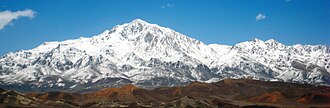
Kūh-e Shah (Persian: کوه شاه; also:Laleh zar) The king Mountain is a mountain in the central Iranian mountain range in the south east of Iran, in Kerman Province.1 It is located in the Baft county of the Kerman Province.2 Elevation of this mountain is 4,384 meters at the peak.3
References
References
- "Shahdag". web.archive.org. Archived from the original on 2016-08-21. Retrieved 2016-08-21.
- "Shah Dhar Mountain Information". mountain-forecast.com. Retrieved 2016-08-21.
- "Shah Mountain - Picture of Shah Mountain, Baft - TripAdvisor". tripadvisor.co.uk. Retrieved 2016-08-21.
http://peaklist.org/WWlists/ultras/iran.html