Kalar
کەلار Kelar | |
|---|---|
City | |
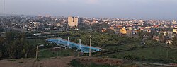 The view of Kalar from Sherwana Castle | |
Kalar Kalar in Iraq | |
| Coordinates: 34°37′45″N 45°19′20″E / 34.62917°N 45.32222°E / 34.62917; 45.32222 | |
| Country |  Iraq Iraq |
| Autonomous Region |  Kurdistan Region Kurdistan Region |
| Governorate | Sulaymaniyah |
| District | Kalar |
| Elevation | 200–2551 m (656–837 ft) |
| Population (2018)2 | |
• Total | 149,8601 |
| Time zone | UTC+3 (UTC+3) |
| Postal code | 46021 |
Kalar (Arabic: كلار; Sorani Kurdish: کەلار, romanized: Kelar)34 is a city in the Kurdistan Region of Iraq and is the administrative center of the Garmian Region. It is located on the west bank of the Sirwan (Diyala) river in Sulaymaniyah Governorate, east of Kifri, and west of the towns of Qasri Shirin and Sarpol Zahab, located in Kermanshah.1
Climate
Kalar is located in the Garmian Region in Southern Kurdistan and is known for having a warm and dry climate, occasionally reaching over 50°C (122°F) in the summer. It is warmest in July and coldest in January. The temperature rarely reaches below 0°C (32°F) in the winter. According to the Köppen-Geiger climate classification system, Kalar has a Semi-arid climate (BSh).
| Climate data for Kalar, Iraq | |||||||||||||
|---|---|---|---|---|---|---|---|---|---|---|---|---|---|
| Month | Jan | Feb | Mar | Apr | May | Jun | Jul | Aug | Sep | Oct | Nov | Dec | Year |
| Record high °C (°F) | 19.24 (66.63) |
20.26 (68.47) |
28.36 (83.05) |
31.4 (88.5) |
38.49 (101.28) |
45.58 (114.04) |
47.6 (117.7) |
45.58 (114.04) |
43.55 (110.39) |
27.35 (81.23) |
35.45 (95.81) |
25.32 (77.58) |
47.6 (117.7) |
| Mean daily maximum °C (°F) | 9.76 (49.57) |
11.52 (52.74) |
15.92 (60.66) |
21.86 (71.35) |
28.62 (83.52) |
36.04 (96.87) |
40.25 (104.45) |
40.18 (104.32) |
35.11 (95.20) |
17.81 (64.06) |
27.02 (80.64) |
12.28 (54.10) |
24.70 (76.46) |
| Daily mean °C (°F) | 6.54 (43.77) |
7.94 (46.29) |
11.94 (53.49) |
17.56 (63.61) |
24.42 (75.96) |
31.46 (88.63) |
35.46 (95.83) |
35.08 (95.14) |
30.07 (86.13) |
14.06 (57.31) |
22.51 (72.52) |
8.83 (47.89) |
20.49 (68.88) |
| Mean daily minimum °C (°F) | 1.81 (35.26) |
2.54 (36.57) |
5.3 (41.5) |
9.31 (48.76) |
15.06 (59.11) |
20.84 (69.51) |
24.39 (75.90) |
24.39 (75.90) |
20.05 (68.09) |
8.3 (46.9) |
14.58 (58.24) |
4.0 (39.2) |
12.55 (54.58) |
| Record low °C (°F) | −8.1 (17.4) |
−7.09 (19.24) |
−8.1 (17.4) |
0.0 (32.0) |
5.06 (41.11) |
14.18 (57.52) |
18.23 (64.81) |
15.19 (59.34) |
12.15 (53.87) |
−4.05 (24.71) |
7.09 (44.76) |
−8.1 (17.4) |
−8.1 (17.4) |
| Average precipitation mm (inches) | 165.46 (6.51) |
145.91 (5.74) |
182.21 (7.17) |
89.01 (3.50) |
68.4 (2.69) |
2.57 (0.10) |
0.58 (0.02) |
0.78 (0.03) |
1.69 (0.07) |
89.18 (3.51) |
52.39 (2.06) |
137.55 (5.42) |
935.73 (36.82) |
| Average precipitation days | 10.69 | 11.41 | 13.81 | 10.58 | 7.83 | 0.83 | 0.27 | 0.36 | 0.46 | 7.45 | 5.34 | 9.48 | 78.51 |
| Average relative humidity (%) | 63.74 | 63.46 | 60.71 | 53.37 | 39.0 | 21.31 | 16.53 | 16.73 | 20.65 | 33.31 | 47.82 | 57.98 | 41.22 |
| Mean daily sunshine hours | 7.8 | 7.89 | 10.49 | 12.95 | 14.08 | 14.66 | 14.53 | 14.08 | 12.47 | 9.6 | 8.38 | 7.84 | 11.23 |
| Source: 5 | |||||||||||||
Notable inhabitants
- Kawa Garmeyani (1981-2013), Kurdish journalist
See also
See also
- Garmekan (Sasanian province located in modern-day Kurdistan Region of Iraq)
- Garmian Region
- Beth Garmai
References
References
- "Kalar | Unbelievable Kurdistan - Official Tourism Site of Kurdistan". bot.gov.krd. Retrieved 2024-04-24.
- "Kalar – Population – World City Population". CityPopulation.de. Retrieved 19 March 2026.
- خالد محمود کریم (July 2018). "کهلار و دهوروبهرى لهبهر ڕۆشنایى سهرچاوه مێژووییهکاندا (1800-1900ز)". Journal of Garmian University (in Kurdish). 5 (3): 111–136. doi:10.24271/garmian.367. ISSN 2522-3879. Retrieved 21 December 2019.
- "Li Başûrê Kurdistanê bûyereke dijwar a trafîkê: 2 kes mirin". Rûdaw (in Kurdish). 16 June 2019. Retrieved 21 December 2019.
- Kalar weather. "Kalar climate: Average Temperature, weather by month, Kalar weather averages - Climate-Data.org". weatherandclimate.com/.