Kâhta | |
|---|---|
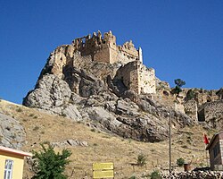 Kâhta castle | |
Location in Turkey | |
| Coordinates: 37°46′49″N 38°37′18″E / 37.78028°N 38.62167°E / 37.78028; 38.62167 | |
| Country | Turkey |
| Province | Adıyaman |
| District | Kâhta |
| Government | |
| • Mayor | Mehmet Can Hallaç (AKP) |
| Population (2021)1 | 86,232 |
| Time zone | UTC+3 (TRT) |
| Postal code | 02400 |
| Website | www |
Kâhta (Turkish pronunciation: [ˈcahta]; Kurdish: Kolîk,2 Ottoman Turkish: کولک, romanized: Kölük3) is a city in Adıyaman Province of Turkey. It is the seat of Kâhta District.4 Its population is 86,232 (2021).1 The city is populated by Kurds from the Reşwan tribe.25
Neighborhoods
The town is divided into the neighborhoods of Atatürk, Bağlar, Bayraktar, Cami, Cumhuriyet, Çobanlı, Fatih, Fırat, Gazi, Girne, Hürriyet, Karşıyaka, Menderes, Şeyhbaba, Turanlı, Turgut Özal, Yavuz Selim and Yeni.4
Climate
Kâhta has a hot-summer Mediterranean climate (Köppen: Csa),6 with pronounced seasons. Summers are very hot and dry, and winters are cool and wet.
| Climate data for Kâhta (1991–2020) | |||||||||||||
|---|---|---|---|---|---|---|---|---|---|---|---|---|---|
| Month | Jan | Feb | Mar | Apr | May | Jun | Jul | Aug | Sep | Oct | Nov | Dec | Year |
| Mean daily maximum °C (°F) | 8.4 (47.1) |
10.1 (50.2) |
15.1 (59.2) |
20.6 (69.1) |
26.9 (80.4) |
33.5 (92.3) |
38.0 (100.4) |
38.0 (100.4) |
32.9 (91.2) |
25.8 (78.4) |
16.8 (62.2) |
10.5 (50.9) |
23.1 (73.6) |
| Daily mean °C (°F) | 4.6 (40.3) |
5.8 (42.4) |
10.1 (50.2) |
15.0 (59.0) |
20.7 (69.3) |
27.1 (80.8) |
31.4 (88.5) |
31.3 (88.3) |
26.2 (79.2) |
19.8 (67.6) |
11.8 (53.2) |
6.6 (43.9) |
17.6 (63.7) |
| Mean daily minimum °C (°F) | 1.7 (35.1) |
2.3 (36.1) |
5.9 (42.6) |
9.9 (49.8) |
14.8 (58.6) |
20.8 (69.4) |
25.1 (77.2) |
24.5 (76.1) |
20.1 (68.2) |
14.9 (58.8) |
8.1 (46.6) |
3.6 (38.5) |
12.7 (54.9) |
| Average precipitation mm (inches) | 130.94 (5.16) |
99.36 (3.91) |
75.45 (2.97) |
59.96 (2.36) |
34.42 (1.36) |
8.23 (0.32) |
1.24 (0.05) |
0.71 (0.03) |
7.34 (0.29) |
48.28 (1.90) |
74.8 (2.94) |
124.78 (4.91) |
665.51 (26.20) |
| Average precipitation days (≥ 1.0 mm) | 9.2 | 9.0 | 8.0 | 6.8 | 4.7 | 1.7 | 1.1 | 1.2 | 2.5 | 4.4 | 6.2 | 9.0 | 63.8 |
| Average relative humidity (%) | 65.3 | 62.9 | 58.2 | 56.3 | 48.6 | 32.8 | 26.0 | 27.4 | 31.4 | 43.2 | 55.6 | 65.9 | 47.7 |
| Source: NOAA7 | |||||||||||||
Notable people
- Dengir Mir Mehmet Fırat (1943-2019), Kurdish politician who was one of the founders of the Justice and Development Party (AKP) in 2001
- Ahmet Aydın (*1971), Kurdish Politician
- Mehmet Yavuz (1973-2019), Kurdish politician and teacher in Turkey who led the Kurdish Islamist Free Cause Party from May 2018 until 7 October 2018
References
References
- "Address-based population registration system (ADNKS) results dated 31 December 2021" (XLS) (in Turkish). TÜİK. Retrieved 12 January 2023.
- Oncu, Mehmet (2023). Binemal û hozên li herêma Semsûrê (in Kurdish). Sîtav. p. 299.
- Tahir Sezen, Osmanlı Yer Adları (Alfabetik Sırayla), T.C. Başbakanlık Devlet Arşivleri Genel Müdürlüğü, Yayın Nu 21, Ankara, p. 264.
- İlçe Belediyesi Archived 2015-07-06 at the Wayback Machine, Turkey Civil Administration Departments Inventory. Retrieved 12 January 2023.
- Kaiser, Hilmar (2019). "Financing the Ruling Party and Its Militants in Wartime: The Armenian Genocide and the Kemah Massacres of 1915". Études arméniennes contemporaines. 12 (12): 7–31. doi:10.4000/eac.1942.
- "Table 1 Overview of the Köppen-Geiger climate classes including the defining criteria". Nature: Scientific Data.
- "World Meteorological Organization Climate Normals for 1991-2020 — Kâhta". National Oceanic and Atmospheric Administration. Retrieved January 15, 2024.