| Jacques Range | |
|---|---|
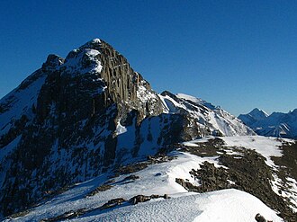 Roche Jacques from the summit of Cinquefoil Mountain | |
| Highest point | |
| Peak | Mount Merlin1 |
| Elevation | 2,711 m (8,894 ft)2 |
| Listing | Mountains of Alberta |
| Coordinates | 52°59′07″N 117°50′07″W / 52.98528°N 117.83528°W / 52.98528; -117.835283 |
| Dimensions | |
| Area | 121 km2 (47 mi2)1 |
| Geography | |
Jacques Range Location in Alberta | |
Country | Canada |
Province | Alberta |
Protected area | Jasper National Park |
Range coordinates | 53°01′N 117°55′W / 53.017°N 117.917°W / 53.017; -117.9174 |
| Parent range | Front Ranges |
| Topo map | NTS 83F4 Miette4 |
The Jacques Range is a mountain range in the Front Ranges of the Canadian Rockies, located south of Highway 16 and Jasper Lake in Jasper National Park, Alberta, Canada.
This range includes the following mountains and peaks:5
| Name | Elevation (m/ft) | |
|---|---|---|
| Mount Merlin | 2,711 | 8,894 |
| Emir Mountain | 2,616 | 8,583 |
| Roche Jacques | 2,603 | 8,540 |
| Merlin Ridge | 2,362 | 7,749 |
| Cinquefoil Mountain | 2,260 | 7,410 |
References
References
- "Jacques Range". bivouac.com. Retrieved 2020-04-26.
- "Topographic map of Mount Merlin". opentopomap.org. Retrieved 2023-07-17.
- "Mount Merlin". Geographical Names Data Base. Natural Resources Canada. Retrieved 2023-07-17.
- "Jacques Range". Geographical Names Data Base. Natural Resources Canada. Retrieved 2020-04-26.
- "Jacques Range". cdnrockiesdatabases.ca. Retrieved 2020-04-26.