Ittenthal | |
|---|---|
 | |
 Flag  Coat of arms | |
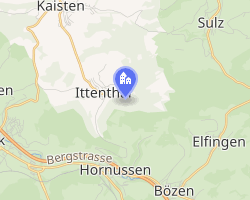 Location of Ittenthal | |
Ittenthal Ittenthal | |
| Coordinates: 47°31′N 8°04′E / 47.517°N 8.067°E / 47.517; 8.067 | |
| Country | Switzerland |
| Canton | Aargau |
| District | Laufenburg |
| Area | |
• Total | 3.89 km2 (1.50 sq mi) |
| Elevation | 404 m (1,325 ft) |
| Population (December 2006) | |
• Total | 201 |
| • Density | 51.7/km2 (134/sq mi) |
| Time zone | UTC+01:00 (CET) |
| • Summer (DST) | UTC+02:00 (CEST) |
| Postal code | 5083 |
| SFOS number | 4168 |
| ISO 3166 code | CH-AG |
| Surrounded by | Frick, Hornussen, Kaisten, Sulz |
| Website | www.ittenthal.ch |
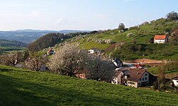
Ittenthal was a municipality in the district of Laufenburg in the canton of Aargau in Switzerland. On 1 January 2010, Ittenthal merged into the municipality of Kaisten.1
The historical population is given in the following table:2
| year | population |
|---|---|
| 1803 | 171 |
| 1850 | 265 |
| 1900 | 217 |
| 1950 | 221 |
| 2000 | 222 |
References
References
- Amtliches Gemeindeverzeichnis der Schweiz, Mutationsmeldungen 2009 / Répertoire officiel des communes de Suisse, Mutations 2009 / Elenco ufficiale dei Comuni della Svizzera, Mutazione 2009 (PDF) (Report). Federal Statistical Office. 2009. 3171. Archived from the original (PDF) on 18 November 2010. Retrieved 6 March 2010.
- "Ittenthal" in German, French and Italian in the online Historical Dictionary of Switzerland.
External links
External links
- "Ittenthal" in German, French and Italian in the online Historical Dictionary of Switzerland.