| Huaypun | |
|---|---|
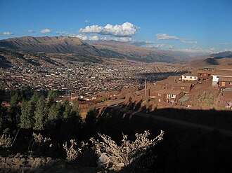 Cusco with the mountains Pillku Urqu (on the left), Pachatusan (center) and Huaypun in the background | |
| Highest point | |
| Elevation | 4,200 m (13,800 ft)1 |
| Coordinates | 13°32′54″S 71°45′42″W / 13.54833°S 71.76167°W / -13.54833; -71.76167 |
| Naming | |
Language of name | Quechua |
| Geography | |
Huaypun Peru | |
| Location | Peru, Cusco Region, Calca Province |
| Parent range | Andes |
Huaypun (possibly from Quechua waypu a name applied for different species of Tinamidae, Nothoprocta pentlandii, Rhynchotus rufescens and Rhynchotus maculicollis,23 -n a suffix) is a mountain in the Cusco Region in Peru, about 4,200 metres (13,780 ft) high. It is situated in the Calca Province, San Salvador District, and in the Quispicanchi Province, Oropesa District.1 Huaypun lies on the western bank of the Vilcanota River, southeast of Pachatusan and southwest of Tauja.
References
References
- escale.minedu.gob.pe - UGEL map of the Calca Province (Cusco Region) (unnamed)
- Martín R. de la Peña, Diccionario de nombres vulgares de las Aves de Argentina, Serie Naturaleza, Conservación y Sociedad, No. 1, 2011
- Juan Carlos Chebez, Alejandro Mouchard, Lucas Rodríguez, Ornitonimia popular y científica de las aves argentinas II. (Tinamiformes, Sphenisciformes y Podicipediformes), in Nótulas Faunísticas, Segunda Serie, 65, 2011, see p. 5: Rhynchotus maculicollis Gray, 1867 (guaipo, huaipo, guaypo, waypo (QU))