Hottwil | |
|---|---|
 | |
 Flag  Coat of arms | |
 Location of Hottwil | |
Hottwil Hottwil | |
| Coordinates: 47°33′N 8°10′E / 47.550°N 8.167°E / 47.550; 8.167 | |
| Country | Switzerland |
| Canton | Aargau |
| District | Brugg |
| Area | |
• Total | 4.16 km2 (1.61 sq mi) |
| Elevation | 415 m (1,362 ft) |
| Population (December 2006) | |
• Total | 262 |
| • Density | 63.0/km2 (163/sq mi) |
| Time zone | UTC+01:00 (CET) |
| • Summer (DST) | UTC+02:00 (CEST) |
| Postal code | 5277 |
| SFOS number | 4101 |
| ISO 3166 code | CH-AG |
| Surrounded by | Gansingen, Mandach, Remigen, Villigen, Wil |
| Website | www.hottwil.ch |
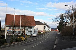
Hottwil was a municipality in the district of Brugg in canton of Aargau in Switzerland. On 1 January 2010 the municipalities of Hottwil, Etzgen, Mettau, Oberhofen and Wil merged to form the new municipality of Mettauertal.1 This resulted in Hottwil transferring from the Brugg to the Laufenburg district.
References
References
- Amtliches Gemeindeverzeichnis der Schweiz, Mutationsmeldungen 2009 / Répertoire officiel des communes de Suisse, Mutations 2009 / Elenco ufficiale dei Comuni della Svizzera, Mutazione 2009 (PDF) (Report). Federal Statistical Office. 2009. 3170. Archived from the original (PDF) on 18 November 2010. Retrieved 6 March 2010.
External links
External links
- "Hottwil" in German, French and Italian in the online Historical Dictionary of Switzerland.