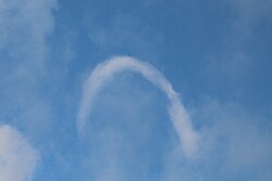
A horseshoe cloud is a relatively uncommon meteorological phenomenon1 which manifests as a cloud in the shape of a horseshoe or inverted letter "U".12
They occur when a horseshoe vortex deforms a cumulus cloud.2 The clouds are relatively short-lived2 and is the last stage before one dissipates.3 Horseshoe vortex clouds are a form of "fair-weather" funnel cloud and are similar to the shear funnel type of funnel cloud.
A March 2018 instance was explained by the United States National Weather Service:45
As the updraft pushes flattish cumulus clouds up & a horizontal vortex develops from differential updraft speeds... As the vortex climbs, it's caught in the faster horizontal winds aloft, & the middle part of the vortex catches the faster speeds with the ends being slower.
These clouds do not occur often because all the needed conditions rarely occur together.3
References
References
- "Horseshoe Vortex Cloud (February 07)". Cloud Appreciation Society. January 31, 2007. Retrieved March 12, 2018.
- "An incredibly rare 'horseshoe cloud' was spotted in Nevada and it kept the meme-makers busy". Independent.ie. March 12, 2018. Retrieved March 12, 2018.
- Baer, Stephanie K. (March 10, 2018). "People On Twitter Are Freaking Out Over This Rare Type Of Cloud". BuzzFeed News. Retrieved February 2, 2023.
- @NWSElko (March 9, 2018). "As the updraft pushes flattish cumulus clouds up & a horizontal vortex develops from differential updraft speeds..." (Tweet) – via Twitter.
- @NWSElko (March 9, 2018). "As the vortex climbs, it's caught in the faster horizontal winds aloft,& the middle part of the vortex catches the faster speeds with the ends being slower" (Tweet) – via Twitter.