| Holåbreen | |
|---|---|
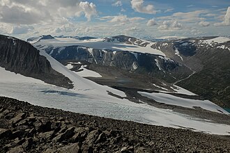 Eastern part of the glacier | |
 Interactive map of the glacier | |
| Location | Vestland and Innlandet, Norway |
| Coordinates | 61°45′24″N 7°54′09″E / 61.75667°N 7.90250°E / 61.75667; 7.90250 |
| Area | 20 km2 (7.7 sq mi) |
Holåbreen1 is a glacier in the Breheimen mountain range of Norway. It is located on the border of Skjåk Municipality in Innlandet county and Luster Municipality in Vestland county. The 20-square-kilometre (7.7 sq mi) glacier lies between the mountains Gjelhøi and Holåtindan. 2
References
References
- "Informasjon om stadnamn". Norgeskart (in Norwegian). Kartverket. Retrieved 24 August 2025.
- Lauritzen, Per Roger, ed. (2009). "Holåbreen". Norsk Fjelleksikon (in Norwegian). Arendal: Friluftsforlaget. p. 156. ISBN 9788291495477.