| High Green near Barnsley | |
|---|---|
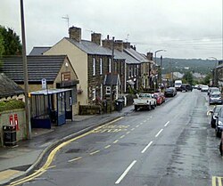 Wortley Road, High Green | |
High Green near Barnsley Location within Sheffield | |
| Civil parish | |
| Metropolitan borough | |
| Metropolitan county | |
| Region | |
| Country | England |
| Sovereign state | United Kingdom |
| Post town | SHEFFIELD |
| Postcode district | S35 |
| Dialling code | 01141 |
| Police | South Yorkshire |
| Fire | South Yorkshire |
| Ambulance | Yorkshire |
| UK Parliament | |
High Green is a village situated approximately 6 miles from Barnsley, the nearest major town. It is located to the north of Chapeltown and is served by bus services; the nearest railway station is in Chapeltown, 1 mile away. The suburb falls within the West Ecclesfield ward of the city Council. Wharncliffe Crags are nearby, as is Westwood Country Park.Until April 1974 High Green was part of the Wortley Rural District, in the West Riding of Yorkshire.
High Green has five primary schools: four mainstream schools (Angram Bank Primary, High Green Primary, Greengate Lane Primary, and St. Mary's Primary) and one non-maintained special school, Paces School—formerly High Green Secondary—for both primary and secondary age children. High Green does not have a mainstream secondary school. Pupils typically attend Ecclesfield School, located approximately 2 miles away in the Ecclesfield area. Other secondary schools in the vicinity include Stocksbridge or Notre Dame.
References
References
- "Ofcom | Telecoms numbering". Stakeholders.ofcom.org.uk. 28 April 2010. Retrieved 31 March 2014.