Hesborn | |
|---|---|
 | |
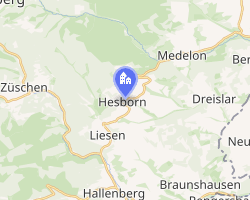 Location of Hesborn | |
Hesborn Hesborn | |
| Coordinates: 51°8′58.78″N 8°37′38.79″E / 51.1496611°N 8.6274417°E / 51.1496611; 8.6274417 | |
| Country | Germany |
| State | North Rhine-Westphalia |
| Admin. region | Arnsberg |
| District | Hochsauerlandkreis |
| Municipality | Hallenberg |
| Area | |
• Total | 14.18 km2 (5.47 sq mi) |
| Highest elevation | 522 m (1,713 ft) |
| Lowest elevation | 459 m (1,506 ft) |
| Population (2010) | |
• Total | 1,060 |
| • Density | 74.8/km2 (194/sq mi) |
| Time zone | UTC+01:00 (CET) |
| • Summer (DST) | UTC+02:00 (CEST) |
| Postal codes | 59969 |
| Dialling codes | 02984 |
| Vehicle registration | HSK |
| Website | Official website |
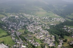
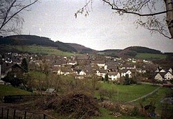
Hesborn is a village and a civil parish (Ortsteil) of the German town of Hallenberg, located in the Hochsauerlandkreis district in North Rhine-Westphalia. As of 2010 its population was of 1,060.1
History
The village was first mentioned as Hersporen in 1126. As the two other Ortsteil of Hallenberg Hesborn was, until 1974, an autonomous municipality belonging to the former District of Brilon and to the Amt Hallenberg. In 1975 it was incorporated into the city of Hallenberg.
Geography
Hesborn is located 4,5 km in north of Hallenberg, close to Liesen and to the Bollerberg, a mountain belonging to the mountain range of Rothaargebirge. It is 7 km far from Bromskirchen, a municipality in the bordering state of Hesse. It is served by the road L617 and crossed by the river Nuhne.
References
References
- (in German) "Amtliche Bevölkerungszahlen" Archived 2011-09-28 at the Wayback Machine. Landesbetrieb Information und Technik NRW. 31 December 2010.
External links
External links
- (in German) Hesborn official website Archived 2011-11-15 at the Wayback Machine