Herronton | |
|---|---|
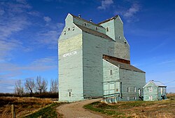 Grain elevator in Herronton, Alberta | |
Herronton Location of Herronton Show map of AlbertaHerronton Herronton (Canada) Show map of Canada | |
| Coordinates: 50°37′29″N 113°26′22″W / 50.62472°N 113.43944°W / 50.62472; -113.43944 | |
| Country | Canada |
| Province | Alberta |
| Region | Southern Alberta |
| Census division | 5 |
| Municipal district | Vulcan County |
| Government | |
| • Type | Unincorporated |
| • Governing body | Vulcan County Council |
| Population (2007)1 | |
• Total | 10 |
| Time zone | UTC−06:00 (Alberta Time) |
| Area codes | 403, 587, 825 |
Herronton is a hamlet in southern Alberta, Canada within Vulcan County.2 It is located 6 kilometres (3.7 mi) north of Highway 23, approximately 64 kilometres (40 mi) southeast of Calgary. The post office was opened in 1912 and named after John Herron of the North-West Mounted Police.3
Demographics
The population of Herronton according to the 2007 municipal census conducted by Vulcan County is 10.1
References
References
- "Alberta Population Summary: Alberta's Hamlets Alphabetically, 2010" (PDF). Alberta Population. Archived from the original (PDF) on December 11, 2021. Retrieved September 25, 2021.
- "Specialized and Rural Municipalities and Their Communities" (PDF). Alberta Municipal Affairs. June 3, 2024. Retrieved June 14, 2024.
- Fencelines and Furrows History Book Society (1971). Fencelines and Furrows. p. 41.