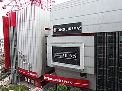
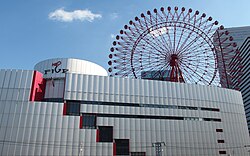
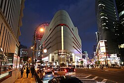

HEP is a major shopping mall and entertainment center in the Umeda commercial district of Kita-ku, Osaka, Japan. It is a shopping mall consisting of a HEP Five and HEP Navio.
HEP stands for "Hankyu Entertainment Park". The building is operated by Hankyu Hanshin Holdings's real estate investment trust (REIT) subsidiary Hankyu REIT and co-owned by Hankyu REIT (45%) and Hankyu Realty Co. (55%).1
HEP Five
HEP Five receives about 17 million visitors annually (2007), making it one of the most visited fashion boutique buildings in the Osaka urban region.2 The core customers at HEP Five are young people, mostly female, from high school age to their early twenties.
The building itself houses over 100 shops (mostly fashion retail shops catering to young consumers), with restaurants, an event hall, amusement facilities (such as Joypolis and the Ferris wheel), a hanging replica of 2 whales designed by Tatsuya Ishii.2
Ferris wheel
The HEP Five building is easily located as it has a large red Ferris wheel with a diameter of 75 metres protruding from its roof (the highest point of the wheel is 106m above the ground, including the height of the building2), which is accessible for a fee.
Building data
| Location | 5–15, Kakuda-cho, Kita-ku, Osaka |
| Lot Area | 5,596.11 m2 |
| Total floor area | 45,266.96 m2 |
| Number of floors | 10 floors, 3 underground levels |
| Completion date | November 1998 |
References
References
- Hankyu REIT sells 5% interest in HEP five to Hankyu Realty (Notice Concerning Transfers of Domestic Real Estate Trust Beneficiary Interests)
- "Hankyu REIT - HEP Five". Archived from the original on 2011-07-22. Retrieved 2009-08-02.
External links
External links
- Official website (in Japanese)
- Official website
- Hep Hall (in Japanese)
- Hankyu REIT
34°42′14″N 135°30′02″E / 34.7040028°N 135.5004466°E / 34.7040028; 135.5004466