| Hazaran | |
|---|---|
| Kuh-e Hazar | |
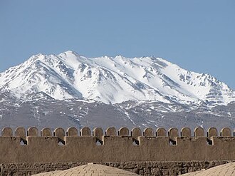 Kuh-e Hazaran seen from Rayen Castle | |
| Highest point | |
| Elevation | 4,500 m (14,800 ft)1 |
| Prominence | 2,741 m (8,993 ft)1 |
| Listing | Ultra |
| Coordinates | 29°30′42″N 57°16′18″E / 29.51167°N 57.27167°E / 29.51167; 57.271671 |
| Geography | |
Hazaran Location in Iran | |
| Location | Central Iranian Plateau, Kerman Province, Iran |
| Parent range | A central Iranian range (Sahand-Bazman volcanic belt or range) east and parallel to the Zagros Mountains |
Hazaran, also Hazar or Hezar (Persian: کوه هزار), is a massif of the Central Iranian Plateau, and an eastern outlier of the Zagros Mountains. Hazaran is located in Kerman province, southeast Iran. With an elevation of 4,500 metres, it is the highest peak in Kerman province. The jebal Barez chain is a continuation to the south-east. The Halil River rises in the Bid Khan region. The massif is situated in the area encircled by the cities of Kerman, Bardsir, Sirjan, Baft, Jiroft and Bam.
Made chiefly of Eocene andesite and pyroclastic rocks,2 Mount Hazar or Hazaran is situated in a central Iranian range, Sahand-Bazman volcanic range or belt, a mountain range which was formed mainly during Eocene volcanism and that stretches approximately from Sahand Volcano in the north-west of Iran to Bazman Volcano in the south-east of Iran.3
Major peaks
- Kuh-e Hazaran (Kūh-e Hazār) 4500 m 4 29°30′42″N 57°16′18″E / 29.51167°N 57.27167°E / 29.51167; 57.271671
- Kuh Shah 4380 m 29°23′28″N 56°44′50″E / 29.39111°N 56.74722°E / 29.39111; 56.74722
- Kuh-e Palvar 4229 m 30°4′14″N 57°27′55″E / 30.07056°N 57.46528°E / 30.07056; 57.46528
- Kuh-e Jupar 4150 m 29°55′N 57°12′E / 29.917°N 57.200°E / 29.917; 57.200
- Kuh-e Khabr 3856 m 28°49′N 56°25′E / 28.817°N 56.417°E / 28.817; 56.417
- Kuh-e Bidkhan 3424 m 29°36′14″N 56°32′49″E / 29.604°N 56.547°E / 29.604; 56.547
References
References
- "Iran: 54 Mountain Summits with Prominence of 1,500 meters or greater". Peaklist.org. Retrieved 2014-05-25.
- Geological Map of Iran, National Geoscience Database of Iran, www.ngdir.ir
- Small, Christopher; Sousa, Daniel (2023-01-18). "Spectral Characteristics of the Dynamic World Land Cover Classification". Remote Sensing. 15 (3): 575. Bibcode:2023RemS...15..575S. doi:10.3390/rs15030575. ISSN 2072-4292.
- "Kūh-e Hazār, Iran". Peakbagger.com. Retrieved 2014-05-25.