Halder | |
|---|---|
Hamlet | |
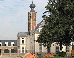 The restored Herlaar Castle | |
Halder Location in the province of North Brabant in the Netherlands Show map of North BrabantHalder Halder (Netherlands) Show map of Netherlands | |
| Coordinates: 51°39′N 5°19′E / 51.650°N 5.317°E / 51.650; 5.317 | |
| Country | Netherlands |
| Province | North Brabant |
| Municipality | Sint-Michielsgestel |
| Area | |
• Total | 0.17 km2 (0.066 sq mi) |
| Population (2021)1 | |
• Total | 70 |
| • Density | 410/km2 (1,100/sq mi) |
| Time zone | UTC+1 (CET) |
| • Summer (DST) | UTC+2 (CEST) |
| Postal code | 52711 |
| Dialing code | 073 |
Halder is a hamlet in the Dutch province of North Brabant. It is located in the municipality of Sint-Michielsgestel, between the towns of Sint-Michielsgestel and Vught.2
The hamlet was first mentioned in 1087 as Herlar, and is a combination of "forest meadow" and "army". It takes its name from the castle.3 Halder has place name signs. It was home to 312 people in 1840.4
Nieuw Herlaar Castle is a 19th-century monastery, however it contains the 15th-century tower of the old castle.5
References
References
- "Kerncijfers wijken en buurten 2021". Central Bureau of Statistics. Retrieved 18 April 2022.
- ANWB Topografische Atlas Nederland, Topografische Dienst and ANWB, 2005.
- "Halder - (geografische naam)". Etymologiebank (in Dutch). Retrieved 18 April 2022.
- "Halder". Plaatsengids (in Dutch). Retrieved 18 April 2022.
- "Monumentnummer: 33630 Kasteel Nieuw Herlaar Halder 6 5271 VK te Sint-Michielsgestel". Dutch Monuments Register (in Dutch). Retrieved 18 April 2022.