| Grapevine Mountains | |
|---|---|
 Grapevine Mountains | |
| Highest point | |
| Peak | Grapevine Peak |
| Elevation | 2,664 m (8,740 ft) |
| Geography | |
Grapevine Mountains | |
Country | United States |
State(s) | California and Nevada |
District(s) | Inyo County and Nye County |
Range coordinates | 36°57′54.778″N 117°8′57.242″W / 36.96521611°N 117.14923389°W / 36.96521611; -117.14923389 |
| Topo map | USGS Grapevine Peak |
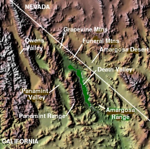
The Grapevine Mountains is a mountain range located along the border of Inyo County, California and Nye County, Nevada in the United States. The mountain range is about 22 miles (35 km) long and lies in a northwest-southeasterly direction along the Nevada-California state line. The range reaches an elevation of 8,738 feet (2,663 m) at Grapevine Peak, near Phinney Canyon on the Nevada side. Daylight Pass is at the southern end of the range. Most of the Grapevine Mountain chain is in Death Valley National Park.
The range was named for the wild grapes in the area.2
References
References
- "Grapevine Mountains". Geographic Names Information System. United States Geological Survey, United States Department of the Interior. Retrieved May 4, 2009.
- Federal Writers' Project (1941). Origin of Place Names: Nevada (PDF). W.P.A. p. 32.
- Allan, Stuart (2005). California Road and Recreation Atlas. Benchmark Maps. p. 81. ISBN 0-929591-80-1.