| Gonzen | |
|---|---|
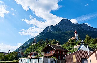 The south face seen from Sargans | |
| Highest point | |
| Elevation | 1,830 m (6,000 ft) |
| Prominence | 162 m (531 ft)1 |
| Parent peak | Gamsberg |
| Coordinates | 47°4′3″N 9°26′2″E / 47.06750°N 9.43389°E / 47.06750; 9.43389 |
| Geography | |
Gonzen Location in Switzerland Show map of SwitzerlandGonzen Location in the canton of St. Gallen Show map of Canton of St. Gallen | |
| Location | Canton of St. Gallen |
Country | Switzerland |
| Parent range | Appenzell Alps |
| Climbing | |
| Easiest route | Trail |
The Gonzen is a 1,830 metres (6,000 ft) high mountain of the Appenzell Alps, overlooking the Rhine Valley above Sargans, in the canton of St. Gallen, Switzerland. It lies at the southeastern end of the Alvier chain (Alvierkette or Alviergruppe), located southeast of the Churfirsten, together with the (from west to east): Gamsberg, Fulfirst, Alvier and Gauschla, among others.
The summit of the Gonzen can be reached via a trail on the northern side.
References
References
- Retrieved from the Swisstopo topographic maps. The key col is located north of the summit at 1,668 metres (5,472 ft).