Gidy | |
|---|---|
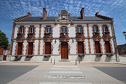 The town hall in Gidy | |
 Coat of arms | |
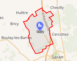 Location of Gidy | |
Gidy Gidy | |
| Coordinates: 47°59′22″N 1°50′08″E / 47.9894°N 1.8356°E / 47.9894; 1.8356 | |
| Country | France |
| Region | Centre-Val de Loire |
| Department | Loiret |
| Arrondissement | Orléans |
| Canton | Meung-sur-Loire |
| Government | |
| • Mayor (2020–2026) | Benoît Perdereau1 |
Area 1 | 23.91 km2 (9.23 sq mi) |
| Population (2023)2 | 2,084 |
| • Density | 87.16/km2 (225.7/sq mi) |
| Demonym | Gidéens |
| Time zone | UTC+01:00 (CET) |
| • Summer (DST) | UTC+02:00 (CEST) |
| INSEE/Postal code | 45154 /45520 |
| Elevation | 117–128 m (384–420 ft) |
| Website | www.gidy.fr |
| 1 French Land Register data, which excludes lakes, ponds, glaciers > 1 km2 (0.386 sq mi or 247 acres) and river estuaries. | |
Gidy (French pronunciation: [ʒidi]) is a commune in the Loiret department in north-central France.
Population
| Year | Pop. | ±% p.a. |
|---|---|---|
| 1968 | 736 | — |
| 1975 | 1,037 | +5.02% |
| 1982 | 1,252 | +2.73% |
| 1990 | 1,450 | +1.85% |
| 1999 | 1,482 | +0.24% |
| 2007 | 1,497 | +0.13% |
| 2012 | 1,647 | +1.93% |
| 2017 | 2,009 | +4.05% |
| 2023 | 2,084 | +0.61% |
| Source: INSEE3 | ||
References
References
- "Répertoire national des élus: les maires". data.gouv.fr, Plateforme ouverte des données publiques françaises (in French). 2 December 2020.
- "Populations de référence 2023" (in French). National Institute of Statistics and Economic Studies. 18 December 2025.
- Population municipale entre 1968 et 2023, INSEE