Gagebrook | |||||||||||||
|---|---|---|---|---|---|---|---|---|---|---|---|---|---|
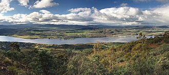 Bridgewater (left) and Gagebrook (right) | |||||||||||||
Gagebrook | |||||||||||||
 Interactive map of Gagebrook | |||||||||||||
| Coordinates: 42°44′40″S 147°16′01″E / 42.7444°S 147.2669°E / -42.7444; 147.2669 | |||||||||||||
| Country | Australia | ||||||||||||
| State | Tasmania | ||||||||||||
| Region | Hobart | ||||||||||||
| City | Hobart | ||||||||||||
| LGA | |||||||||||||
| Location |
| ||||||||||||
| Government | |||||||||||||
| • State electorate | |||||||||||||
| • Federal division | |||||||||||||
| Population | |||||||||||||
| • Total | 1,440 (2016 census)2 | ||||||||||||
| Postcode | 7030 | ||||||||||||
| |||||||||||||
Gagebrook is a residential locality in the local government area (LGA) of Brighton in the Hobart LGA region of Tasmania, Australia. The locality is about 9 kilometres (5.6 mi) south of the town of Brighton. The 2016 census recorded a population of 1440 for the state suburb of Gagebrook.2 It is one of the northernmost suburbs of Hobart, located near the eastern shore of the River Derwent between the suburbs of Bridgewater and Old Beach.
History
Gagebrook was gazetted as a locality in 1977.3 The suburb, like its adjacent suburb of Bridgewater (also built up of mass-public housing in the 1970s) has a reputation as a lower socio-economic area.456 Like the rest of Hobart's public housing suburbs, many public housing stock have been sold privately.
Gagebrook has two primary schools: Herdman's Cove Primary School and Gagebrook Primary School7 (both public).
Geography
The Jordan River forms the western and north-western boundaries.8
Road infrastructure
Route B32 (East Derwent Highway) passes to the south. From there, Gage Road and Tottenham Road provide access to the locality.39
References
References
- Australian Bureau of Statistics (28 June 2022). "Gagebrook (suburb and locality)". Australian Census 2021 QuickStats. Retrieved 28 June 2022.
- "2016 Census Quick Stats Gagebrook (Tas.)". quickstats.censusdata.abs.gov.au. Australian Bureau of Statistics. 23 October 2017. Archived from the original on 8 November 2020. Retrieved 16 January 2021.
- "Placenames Tasmania – Gagebrook". Placenames Tasmania. Select "Search", enter "16959Y", click "Search", select row, map is displayed, click "Details". Retrieved 16 January 2021.
- "On the ground". Griffith Review. Retrieved 7 February 2012.
- Whelan, Jessica J (2001), The dynamics of community reputation : a case study, retrieved 9 March 2017
- Keen, Erica; Fusion Australia; Fusion Southern Tasmania (2006), Research into the community of Bridgewater & Gagebrook, Fusion Australia, retrieved 9 March 2017
- Tasmania. Parliament. Standing Committee on Public Works (1981), New Gagebrook Primary School, Bridgewater, Government Printer, ISBN 978-0-7246-1130-0
- "Gagebrook, Tasmania" (Map). Google Maps. Retrieved 16 January 2021.
- "Tasmanian Road Route Codes" (PDF). Department of Primary Industries, Parks, Water & Environment. May 2017. Archived from the original (PDF) on 1 August 2017. Retrieved 16 January 2021.