| Furgglenfirst | |
|---|---|
| Hintere Hüser | |
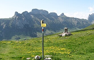 View from the north side | |
| Highest point | |
| Elevation | 1,951 m (6,401 ft) |
| Prominence | 302 m (991 ft)1 |
| Parent peak | Säntis |
| Coordinates | 47°15′24″N 9°26′52″E / 47.25667°N 9.44778°E / 47.25667; 9.44778 |
| Geography | |
Furgglenfirst Location in Switzerland Show map of SwitzerlandFurgglenfirst Location in the canton of Appenzell Innerrhoden Show map of Canton of Appenzell InnerrhodenFurgglenfirst Location in the canton of St. Gallen Show map of Canton of St. Gallen | |
| Location | Appenzell Innerrhoden/St. Gallen |
Country | Switzerland |
| Parent range | Appenzell Alps |
The Furgglenfirst is a multi-summited mountain of the Alpstein massif of the Appenzell Alps located on the border between the Swiss cantons of Appenzell Innerrhoden and St. Gallen.
The main summit, named Hintere Hüser, has a height of 1,951 metres above sea level.
See also
See also
References
References
- Retrieved from the Swisstopo topographic maps. The key col is the Saxerlücke (1,649 m [5,410 ft]).