| Fletcher Mountain | |
|---|---|
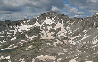 Northeast aspect | |
| Highest point | |
| Elevation | 13,958 ft (4,254 m)12 |
| Prominence | 611 ft (186 m)2 |
| Parent peak | Quandary Peak2 |
| Isolation | 1.27 mi (2.04 km)2 |
| Coordinates | 39°24′12″N 106°07′44″W / 39.4033212°N 106.1289099°W / 39.4033212; -106.12890993 |
| Geography | |
Fletcher Mountain Location within Colorado | |
| Location | Summit County, Colorado, U.S.3 |
| Parent range | Mosquito Range, Tenmile Range2 |
| Topo map(s) | USGS 7.5' topographic map Copper Mountain, Colorado3 |
Fletcher Mountain is a high mountain summit in the Tenmile Range of the Rocky Mountains of North America. The 13,958-foot (4,254 m) thirteener is located in Arapaho National Forest, 8.1 miles (13.0 km) southwest by south (bearing 215°) of the Town of Breckenridge in Summit County, Colorado, United States.123
Climate
According to the Köppen climate classification system, Fletcher Mountain is located in an alpine subarctic climate zone with cold, snowy winters, and cool to warm summers.4 Due to its altitude, it receives precipitation all year, as snow in winter, and as thunderstorms in summer, with a dry period in late spring.
See also
See also
References
References
- The elevation of Fletcher Mountain includes an adjustment of +2.037 m (+6.68 ft) from NGVD 29 to NAVD 88.
- "Fletcher Mountain, Colorado". Peakbagger.com. Retrieved November 5, 2014.
- "Fletcher Mountain". Geographic Names Information System. United States Geological Survey, United States Department of the Interior. Retrieved November 5, 2014.
- Peel, M. C.; Finlayson, B. L.; McMahon, T. A. (2007). "Updated world map of the Köppen-Geiger climate classification" (PDF). Hydrology and Earth System Sciences. 11 (5): 1633–1644. Bibcode:2007HESS...11.1633P. doi:10.5194/hess-11-1633-2007. Archived (PDF) from the original on December 2, 2019. Retrieved November 7, 2025.