 | |
 Interactive map of Fetokopunga | |
| Geography | |
|---|---|
| Location | South Pacific |
| Coordinates | 20°18′07″S 174°32′02″W / 20.302°S 174.534°W / -20.302; -174.534 (Fetokopunga) |
| Archipelago | Haʻapai |
| Highest elevation | 27 m (89 ft) |
| Administration | |
| Division | Haʻapai |

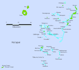
Fetokopunga (also: Fetokobuga, Fetokobunga) is an island in the Haʻapai archipelago that belongs to the Kingdom of Tonga.1 Among neighboring islands are Nukutula, Kelefesia, Nomuka, Nukufaiau, Tonumea, Fonoifua, Telekitonga.23
Geography
The island lies to the east of 'Otu Mu'omu'a as the northernmost tip of the 'Otu Tolu Group, whose islands Telekivava'u, Nukutavake and Telekiha'apai, and Telekitonga join to the south.
Climate
The climate is tropical, but moderated by constantly blowing winds. Like the other islands in the Ha'apai group, Telekitonga is occasionally hit by cyclones.
References
References
- Craig, Robert D. (2011). Historical Dictionary of Polynesia. Rowman & Littlefield. p. 334. ISBN 978-0-8108-6772-7. Retrieved 6 July 2023.
- Kumar, Lalit (31 January 2020). Climate Change and Impacts in the Pacific. Springer Nature. p. 154. ISBN 978-3-030-32878-8. Retrieved 6 July 2023.
- Eustis, Nelson (1997). The King of Tonga: A Biography. Hobby Investment. p. 10. ISBN 978-0-646-33077-8. Retrieved 6 July 2023.