Fót | |
|---|---|
   | |
 Flag  Coat of arms | |
Fót | |
| Coordinates: 47°37′05″N 19°11′25″E / 47.61812°N 19.19032°E / 47.61812; 19.19032 | |
| Country |  Hungary Hungary |
| County | Pest |
| District | Dunakeszi |
| Area | |
• Total | 37.42 km2 (14.45 sq mi) |
| • Density | 506.9/km2 (1,313/sq mi) |
| Time zone | UTC+1 (CET) |
| • Summer (DST) | UTC+2 (CEST) |
| Postal code | 2151 |
| Area code | (+36) 27 |
| Website | www |
Fót is a town in Pest county, Budapest metropolitan area, Hungary.
Location
Fót is about 17 kilometres (11 miles) north of the edge of Budapest. The North Hungarian foothills lie to the west. The nearest settlement to the west is Dunakeszi, to the northeast are Csomád and Veresegyház, to the east is Mogyoród and Budapest is to the south. The highest point of nearby Somlyó Hill reaches 287 metres (942 feet) above sea level.
Architecture
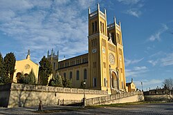
The older areas of Fót feature the notable Catholic Szeplőtelen Fogantatás (Immaculate Conception) Church, built between 1845 and 1855, and the Károlyi Palace, both designed by architect Miklós Ybl.
Notable people
- Gábor Agárdy (1922–2006), actor of Armenian descent
- József Cselényi (1899–1949), singer-songwriter
- Zsolt Erdei (born 1974), professional boxer
- András Fáy (1786–1864), politician and writer
- János Garay (1812–1853), poet, writer and journalist
- Ádám Madaras (born 1966), pentathlete
- András Stohl (born 1967), actor
Twin towns – sister cities
Fót is twinned with:
 Bălăușeri, Romania2
 Batiovo, Ukraine
 San Benedetto dei Marsi, Italy
References
References
- "Official statistics" (in Hungarian). Hungarian Central Statistical Office. Retrieved 2013-02-06.
- "Localităţi înfrăţite". balauseri.ro (in Romanian). Bălăușeri. Retrieved 2021-04-07.
External links
External links
- Official website in Hungarian
- Street map Archived 2007-10-01 at the Wayback Machine (in Hungarian)
- newspapers