Estellencs | |
|---|---|
 Estellencs | |
 Coat of arms | |
 Mpa of Estelllencs in Mallorca | |
Estellencs Estellencs (Balearic Islands) Show map of Balearic IslandsEstellencs Estellencs (Spain) Show map of Spain | |
| Coordinates: 39°39′12″N 2°28′53″E / 39.65333°N 2.48139°E / 39.65333; 2.48139 | |
| Country | |
| Autonomous community | |
| Province | |
| Island | |
| Comarca | Serra de Tramuntana |
| Administrative HQ | Estellencs |
| Government | |
| • Type | Municipal corporation |
| • Body | Ajuntament d'Estellencs |
| • Mayor | Bartomeu Jover Sánchez (PP) |
| Area | |
• Total | 13 km2 (5.0 sq mi) |
| Population (2025-01-01)1 | |
• Total | 369 |
| Time zone | UTC+1 (Central European Time) |
| • Summer (DST) | UTC+2 (Central European Summer Time) |
| Website | www.ajestellencs.net |
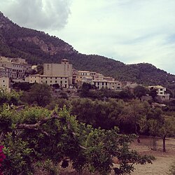
Estellencs (Catalan pronunciation: [əstəˈʎəŋks]) is a municipality in Mallorca in the Balearic Islands, Spain. The village of the same name is the administrative seat of the municipality. It borders the municipalities of Andratx, Calvià, Puigpunyent, and Banyalbufar.
It lies between the Serra de Tramuntana mountain range, on the slopes of Puig de Galatzó (1,026 metres),2 and the Mediterranean Sea.
References
References
- National Statistics Institute (13 December 2025). "Municipal Register of Spain of 2025".
- "Mount Galatzó". Peakware.com. Archived from the original on 2016-03-04.