Erula
| |
|---|---|
| Comune di Erula | |
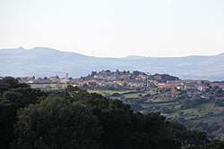 View of Erula | |
Erula Location of Erula in Sardinia | |
| Coordinates: 40°48′N 8°57′E / 40.800°N 8.950°E / 40.800; 8.950 | |
| Country | Italy |
| Region | Sardinia |
| Metropolitan city | Sassari (SS) |
| Frazioni | Sa Mela, Tettile |
| Area | |
• Total | 39.31 km2 (15.18 sq mi) |
| Elevation | 457 m (1,499 ft) |
| Population (2026)2 | |
• Total | 702 |
| • Density | 17.9/km2 (46.3/sq mi) |
| Demonym | Erulesi |
| Time zone | UTC+1 (CET) |
| • Summer (DST) | UTC+2 (CEST) |
| Postal code | 07030 |
| Dialing code | 079 |
Erula (Sardinian: Èrula, Gallurese: Èrula) is a village and comune (municipality) in the Metropolitan City of Sassari in the autonomous island region of Sardinia in Italy, located about 180 kilometres (110 mi) north of Cagliari and about 35 kilometres (22 mi) east of Sassari. It has 702 inhabitants.2
The municipality of Erula contains the frazioni (subdivisions, mainly villages and hamlets) Sa Mela and Tettile.
Erula borders the municipalities of Chiaramonti, Ozieri, Perfugas, Tempio Pausania, and Tula.
Demographics
As of 2026, the population is 702, of which 50.0% are male, and 50.0% are female. Minors make up 12.5% of the population, and seniors make up 31.6%.2
Historical population | |||||||||||||||||||||||||||||||||||||||||||||||||||||||
|
| ||||||||||||||||||||||||||||||||||||||||||||||||||||||
| Source: ISTAT34 | |||||||||||||||||||||||||||||||||||||||||||||||||||||||
Immigration
As of 2025, immigrants make up 2.7% of the population. The 5 largest foreign countries of birth are Romania, Denmark, France, Germany, and the United Kingdom.5
References
References
- "Superficie di Comuni Province e Regioni italiane al 9 ottobre 2011" (in Italian). ISTAT.
- "Resident population". ISTAT.
- "Popolazione residente dei comuni. Censimenti dal 1861 al 1991" [Resident population of the municipalities. Censuses from 1861 to 1991] (PDF) (in Italian). ISTAT. Archived from the original (PDF) on 2025-11-12.
- "Resident population - Time series". ISTAT.
- "Resident population by sex, municipality and citizenship". ISTAT.