Ergolding | |
|---|---|
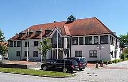 Town hall | |
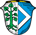 Coat of arms | |
Location of Ergolding
within Landshut district | |
 Location of Ergolding | |
Ergolding Ergolding | |
| Coordinates: 48°35′N 12°10′E / 48.583°N 12.167°E / 48.583; 12.167 | |
| Country | Germany |
| State | Bavaria |
| Admin. region | Niederbayern |
| District | Landshut |
| Subdivisions | 24 Ortsteile |
| Government | |
| • Mayor (2020–26) | Andreas Strauß1 (FW) |
| Area | |
• Total | 37.16 km2 (14.35 sq mi) |
| Elevation | 392 m (1,286 ft) |
| Population (2024-12-31)2 | |
• Total | 13,323 |
| • Density | 358.5/km2 (928.6/sq mi) |
| Time zone | UTC+01:00 (CET) |
| • Summer (DST) | UTC+02:00 (CEST) |
| Postal codes | 84030 |
| Dialling codes | 0871 |
| Vehicle registration | LA |
| Website | www.ergolding.de |
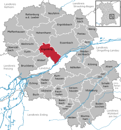
Ergolding (Central Bavarian: Erwading) is a municipality in the district of Landshut, in Bavaria, Germany. It is situated on the left bank of the Isar, 5 km northeast of Landshut.
Heraldry
|
Blazon: Divided per pale argent and azure, in the dexter a rooted green linden tree with seven leaves, in the sinister a silver chevron.
|
References
References
- Liste der ersten Bürgermeister/Oberbürgermeister in kreisangehörigen Gemeinden, Bayerisches Landesamt für Statistik, 15 July 2021.
- "Gemeinden, Kreise und Regierungsbezirke in Bayern, Einwohnerzahlen am 31. Dezember 2024; Basis Zensus 2022" [Municipalities, counties, and administrative districts in Bavaria; Based on the 2022 Census] (CSV) (in German). Bayerisches Landesamt für Statistik.