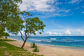
 Eratap beach, Efate in 2008. | |
 Interactive map of Eratap | |
| Geography | |
|---|---|
| Location | Pacific Ocean |
| Coordinates | 17°47′56.8″S 168°20′20.3″E / 17.799111°S 168.338972°E / -17.799111; 168.338972 |
| Archipelago | Vanuatu, Shepherd Islands |
| Highest elevation | 10 m (30 ft) |
| Administration | |
| Province | Shefa Province |
| Demographics | |
| Population | 0 (2015) |

Eratap (also Waratap Island, Îlot Ératap, Castaway Island) is a small uninhabited island in the Pacific Ocean, a part of the Shefa Province of Vanuatu.1
Geography
The island lies 7 km south of Port-Vila and has an upscale resort.2 The estimated terrain elevation above the sea level is some 10 meters3
References
References
- Seech, John. "Eratap Island, Vanuatu". Travel Vanuatu. Archived from the original on 26 October 2017. Retrieved 14 August 2018.
- "Eratap Beach Resort". Vanuatu Travel. Retrieved 14 August 2018.
- "Eratap Island". Mapcarta. Retrieved 14 August 2018.