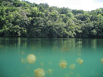
 Jellyfish Lake on Eil Malk | |
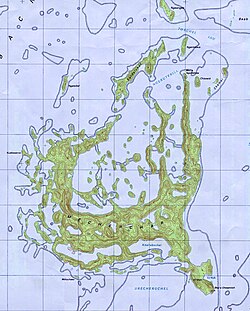 Map of Eil Malk | |
Eil Malk (Mecherchar) | |
| Geography | |
|---|---|
| Location | Pacific Ocean |
| Coordinates | 7°9′15″N 134°21′45″E / 7.15417°N 134.36250°E / 7.15417; 134.36250 |
| Archipelago | Mecherchar Islands, Palau Islands |
| Area | 19 km2 (7.3 sq mi) |
| Length | 6 km (3.7 mi) |
| Width | 4.5 km (2.8 mi) |
| Highest elevation | 82 m (269 ft) |
| Administration | |
Palau | |
| State | Koror |
| Unincorporated area | Rock Islands |
| Demographics | |
| Population | 0 |
| Pop. density | 0/km2 (0/sq mi) |
Eil Malk or Mecherchar is the main island of the Mecherchar Islands, an island group of Palau in the Pacific Ocean. In a more narrow sense, just the southeastern peninsula of Mecherchar is called Eil Malk.1
Geography
Eil Malk is located 23 kilometres (14 mi) southwest of Koror near the fringing reef of Palau. The neighboring island is Ngeruktabel.
This densely wooded, Y-shaped island is up to 6 kilometres (3.7 mi) long and 4.5 kilometres (2.8 mi) wide. There are more than 10 small lakes on the island, including Clear Lake and the most well-known, Jellyfish Lake, located in the eastern part of the island.1
Governance
Eil Malk is uninhabited, but there were at least one, and up to three, villages located there between 1200 and 1450.1
See also
See also
- Desert island – Island without human residentsPages displaying short descriptions of redirect targets
- List of islands
References
References
- "Pacific West Regional Office (U.S. National Park Service)". www.nps.gov. Archived from the original on 2012-11-06. Retrieved 2025-06-03.