Eidsbygda | |
|---|---|
Village | |
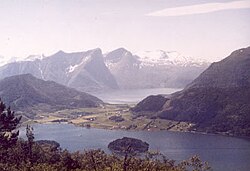 View of Eidsbygda | |
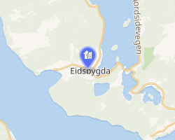 Interactive map of Eidsbygda | |
Eidsbygda Eidsbygda | |
| Coordinates: 62°35′12″N 7°29′42″E / 62.5868°N 7.4950°E / 62.5868; 7.4950 | |
| Country | Norway |
| Region | Western Norway |
| County | Møre og Romsdal |
| District | Romsdal |
| Municipality | Rauma Municipality |
| Elevation | 14 m (46 ft) |
| Time zone | UTC+01:00 (CET) |
| • Summer (DST) | UTC+02:00 (CEST) |
| Post Code | 6350 Eidsbygda |
Eidsbygda2 is a village in Rauma Municipality in Møre og Romsdal county, Norway. It is located 12 kilometres (7.5 mi) northwest of the town of Åndalsnes, on an isthmus of land between the Rødvenfjorden and Romsdal Fjord.
History
This village was the administrative center of the old Eid Municipality. The historic Eid Church is located in the eastern part of Eidsbygda. The village of Rødven (and the historic Rødven Stave Church) lies about 5 kilometres (3.1 mi) to the north of Eidsbygda.
References
References
- "Eidsbygda, Rauma (Møre og Romsdal)". yr.no. Archived from the original on 2016-08-13. Retrieved 2019-07-02.
- "Informasjon om stadnamn". Norgeskart (in Norwegian). Kartverket. Retrieved 2025-03-31.