| Downgate | |
|---|---|
 Downgate | |
Downgate Location within Cornwall | |
| OS grid reference | SX280710 |
| Civil parish | |
| Unitary authority | |
| Ceremonial county | |
| Region | |
| Country | England |
| Sovereign state | United Kingdom |
| Post town | Liskeard |
| Postcode district | PL14 5 |
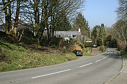
Downgate is a hamlet in east Cornwall, England.1 It is between Pensilva and Upton Cross.2 According to the Post Office the 2011 census population was included in the civil parish of Linkinhorne.
References
References
- Ordnance Survey: Landranger map sheet 201 Plymouth & Launceston (Map). Ordnance Survey. ISBN 978-0-319-23287-3.
- Ordnance Survey One-inch Map of Great Britain; Bodmin and Launceston, sheet 186. 1961