| Dourdou de Conques | |
|---|---|
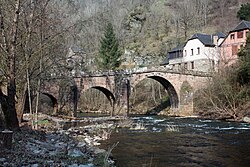 Old bridge in Conques | |
| Location | |
| Country | France |
| Physical characteristics | |
| Source | |
| • location | in Lassouts |
| • coordinates | 44°29′14″N 2°51′28″E / 44.4872°N 2.8577°E / 44.4872; 2.8577 |
| Mouth | |
• location | Lot |
• coordinates | 44°38′09″N 2°21′12″E / 44.6357°N 2.3532°E / 44.6357; 2.3532 |
| Length | 83.7 km (52.0 mi) |
Basin size | 601 km2 (232 sq mi) |
| Basin features | |
| Progression |
Lot→ Garonne→ Gironde estuary→ Atlantic Ocean |
The Dourdou de Conques (French pronunciation: [duʁdu də kɔ̃k], Dourdou of Conques) is an 83.7 km (52.0 mi) long river in the department of Aveyron, southern France.1 Its source is near the village of Lassouts. It flows generally west. It is a left tributary of the Lot, into which it flows near Grand-Vabre.
Communes along its course
The following list is ordered from source to mouth:
- Aveyron: Lassouts, Palmas-d'Aveyron, Gabriac, Bozouls, Rodelle, Muret-le-Château, Villecomtal, Pruines, Mouret, Nauviale, Conques-en-Rouergue