| Local authority district | |
|---|---|
 | |
| Category | Administrative district |
| Location | England |
| Found in | Counties |
| Created by | Local Government Act 1972 London Government Act 1963 |
| Created |
|
| Number | 296 (as of 2024) |
| Possible types |
|
| Possible status | |
| Populations | 2,300 – 1.1 million |
| Areas | 3 – 5,013 km2 (1 – 1,936 sq mi) |
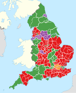
The districts of England (officially, local authority districts, abbreviated LADs) are a level of subnational division of England used for the purposes of local government.1 The two types of district are 132 unitary authorities (which provide all local government services) and 164 two-tier non-metropolitan districts (which share responsnibility with non-metropolitan counties).2 Some districts are styled as cities, boroughs or royal boroughs; these are purely honorific titles and do not alter the status of the district or the powers of their councils. Some unitary authorities are also classified as metropolitan districts and London boroughs. All boroughs and cities, and a few districts, are led by a mayor who in most cases is a ceremonial figure elected by the district council, but in a few places is a directly elected mayor who makes most policy decisions instead of the council.
History
Before the establishment of districts in the 1890s, the basic unit of local government in England was the parish, overseen by the parish church vestry committee. Vestries dealt with the administration of both parochial and secular governmental matters. Parishes were the successors of the manorial system and historically had been grouped into hundreds, which had exercised some supervising administrative function. However, these powers ebbed away as more and more civic and judicial powers were centred on county towns.3 From 1834 these parishes were grouped into Poor Law Unions, creating areas for administration of the Poor Law. These areas were later used for census registration and as the basis for sanitary provision.4 In 1894, based on these earlier subdivisions, the Local Government Act 1894 created urban districts and rural districts as sub-divisions of administrative counties, which had been created in 1889. At the same time, parish-level local government administration was transferred to civil parishes. Another reform in 1900 created 28 metropolitan boroughs as sub-divisions of the County of London.
The setting-down of the current structure of districts in England began in 1965, when Greater London and its 32 London boroughs were created. They are the oldest type of district still in use. In 1974, metropolitan counties and non-metropolitan counties (also known as "shire counties") were created across the rest of England and were split into metropolitan districts and non-metropolitan districts.
The status of the London boroughs and metropolitan districts changed in 1986, when they absorbed the functions and some of the powers of the metropolitan county councils and the Greater London Council, which were abolished. Since 2000, powers are again shared (on a different basis) with the Greater London Authority.
During the 1990s a further kind of district was created, the unitary authority, which combined the functions and status of county and district.
Unitary authorities
There are three main classifications of unitary authority in England: London boroughs, metropolitan districts, and unitary non-metropolitan districts. All are commonly referred to as simply "unitary authorities".5
London boroughs
The 32 London boroughs are sub-divisions of Greater London. They were established in 1965. Between 1965 and 1986 a two-tier structure of government existed in Greater London and the boroughs shared power with the Greater London Council (GLC). When the GLC was abolished in 1986 they became unitary authorities. In 2000 the Greater London Authority was established and a two-tier structure was restored, albeit with a change to the balance of powers and responsibilities.
Each London borough is responsible for many of the services within their area, such as schools, waste management, planning applications, social services, libraries and others.
Metropolitan districts
Metropolitan boroughs are a subdivision of a metropolitan county. These became unitary authorities, as the metropolitan county councils were abolished in 1986. Most of the powers of the county councils were devolved to the districts but some services are run by joint boards and organisations. The districts typically have populations of 174,000 to 1.1 million.
Non-metropolitan districts
All but six of the 62 unitary non-metropolitan districts are also simultaneously classified as non-metropolitan counties. They were first created in the mid-1990s, and often cover large towns and cities as this is deemed more efficient than a two-tier structure. In addition, some of the smaller counties such as Rutland, Herefordshire and the Isle of Wight are unitary authorities. The latest ones were introduced in 2023.
Cornwall, Durham, the Isle of Wight, Northumberland, Shropshire and Wiltshire were established from previous two-tier counties and more commonly use the term "county", but like the other unitary non-metropolitan districts they are legally both counties and districts. The six unitary authorities in Berkshire are not classified as non-metropolitan counties, with Berkshire itself still classified as a non-metropolitan county but one with no administrative functions.
Two-tier non-metropolitan districts
Non-metropolitan districts (other than unitary authorities) are second-tier authorities, which share power with county councils. They are subdivisions of shire counties and the most common type of district. These districts typically have populations of 25,000 to 200,000.
In this two-tier system, county councils are responsible for some local services, such as education, social services, and roads, while district councils run other services, such as waste collection, local planning, and council housing.
The number of two-tier non-metropolitan districts (also known as shire districts) has varied over time. Initially, there were 296; after the creation of single-tier unitary authorities in the 1990s, 2000s, 2010s and 2020s, their numbers were reduced to 164 by 2023.
Districts with their ceremonial or historic county in their names


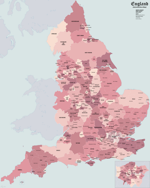
Map
See also
See also
References
References
- "A Beginners Guide to UK Geography (2023)". Open Geography Portal. Office for National Statistics. 24 August 2023. Retrieved 9 December 2023.
- "What is local government reorganisation". Institute for Government. 15 January 2025. Retrieved 26 May 2026.
- Mapping the Hundreds of England and Wales in GIS University of Cambridge Department of Geography, published 06-06-08, accessed 12 October 2011
- Winstanley, Michael (n.d.). "The Poor Law in Cumbria" (PDF). Cumbria County History Trust. Cumbria County History Trust. Retrieved 29 December 2025.
- "Devolution and local government reorganisation FAQs and glossary". Local Government Association. Retrieved 23 May 2026.