Dir
دیر | |
|---|---|
City | |
Dir Dir | |
| Coordinates: 35°12′24″N 71°52′36″E / 35.20667°N 71.87667°E / 35.20667; 71.87667 | |
| Country |  Pakistan Pakistan |
| Province | Khyber Pakhtunkhwa |
| District | Upper Dir District |
| Elevation | 1,420 m (4,660 ft) |
| Population (2023) | |
• Total | 47,828 |
| Time zone | UTC+5 (PKT) |
| Postal code | 18000 |
Dir (Urdu, Pashto: دیر) is a city in the Upper Dir District of the Khyber-Pakhtunkhwa province of Pakistan. It is sometimes known as Dir Khas (Proper Dir) to distinguish it from the district's name, Dir (Upper and Lower). It lies along the Dir River, a tributary of the Panjkora River.1 It is at the base of the Lowarai Pass, the main road to Chitral.
History
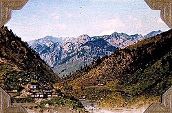
Dir was founded in the 17th century. Mullā Ilyās, a 17th-century holy man, is said to have been the founder.1 It was the capital of the former princely state of Dir, until its full incorporation into Pakistan in 1969.2 The former royal palace is on a hill above the city. Dir was then the capital of the Dir District. When the Dir District was divided in 1996 into Upper and Lower Dir, Dir city and Timergara became its district headquarters respectively. Yusufzay Pashtuns make up the primary ethnic group in the region and in the city.1
Demographics
Population
| Year | Pop. | ±% p.a. |
|---|---|---|
| 1951 | ... | — |
| 1961 | ... | — |
| 1972 | ... | — |
| 1981 | ... | — |
| 1998 | 22,901 | — |
| 2017 | 44,100 | +3.51% |
| 2023 | 47,842 | +1.37% |
| Sources:34 | ||
The population of city in 1998 was 22,901 but according to the 2023 Census of Pakistan, the population has risen to 47,842.56
Climate
Like most of the southern slopes of Khyber Pakhtunkhwa, Dir has a humid subtropical climate (Köppen Cfa). Owing to the city's exposed location, rainfall from frontal cyclones from the west is heavier than in any other part of Pakistan, and their passage, as well as very penetrative monsoonal periods, are usually accompanied by heavy thunderstorms.
| Climate data for Dir, Khyber Pakhtunkhwa | |||||||||||||
|---|---|---|---|---|---|---|---|---|---|---|---|---|---|
| Month | Jan | Feb | Mar | Apr | May | Jun | Jul | Aug | Sep | Oct | Nov | Dec | Year |
| Record high °C (°F) | 22.2 (72.0) |
23.9 (75.0) |
30.6 (87.1) |
33.9 (93.0) |
38.1 (100.6) |
41.5 (106.7) |
38.1 (100.6) |
37.4 (99.3) |
35.0 (95.0) |
33.9 (93.0) |
28.0 (82.4) |
23.0 (73.4) |
41.5 (106.7) |
| Mean daily maximum °C (°F) | 11.3 (52.3) |
12.0 (53.6) |
16.1 (61.0) |
22.5 (72.5) |
27.9 (82.2) |
32.4 (90.3) |
31.2 (88.2) |
30.1 (86.2) |
28.9 (84.0) |
25.3 (77.5) |
20.1 (68.2) |
13.9 (57.0) |
22.6 (72.7) |
| Daily mean °C (°F) | 4.4 (39.9) |
5.3 (41.5) |
9.5 (49.1) |
15.0 (59.0) |
19.8 (67.6) |
23.9 (75.0) |
25.1 (77.2) |
24.2 (75.6) |
21.2 (70.2) |
16.3 (61.3) |
11.2 (52.2) |
6.4 (43.5) |
15.1 (59.2) |
| Mean daily minimum °C (°F) | −2.5 (27.5) |
−1.5 (29.3) |
3.0 (37.4) |
7.6 (45.7) |
11.6 (52.9) |
15.5 (59.9) |
19.1 (66.4) |
18.3 (64.9) |
13.5 (56.3) |
7.3 (45.1) |
2.4 (36.3) |
−1.2 (29.8) |
7.8 (46.0) |
| Record low °C (°F) | −10.6 (12.9) |
−13.9 (7.0) |
−4.4 (24.1) |
−1.1 (30.0) |
2.9 (37.2) |
8.3 (46.9) |
10.0 (50.0) |
7.9 (46.2) |
3.3 (37.9) |
0.1 (32.2) |
−7.2 (19.0) |
−9.4 (15.1) |
−13.9 (7.0) |
| Average precipitation mm (inches) | 120.6 (4.75) |
176.7 (6.96) |
253.7 (9.99) |
178 (7.0) |
86.1 (3.39) |
54.4 (2.14) |
160.0 (6.30) |
168.6 (6.64) |
83.7 (3.30) |
50.3 (1.98) |
58.1 (2.29) |
90.3 (3.56) |
1,480.5 (58.3) |
| Mean monthly sunshine hours | 131.6 | 129.7 | 145.8 | 195.4 | 254.2 | 282.4 | 247.1 | 223.8 | 224.1 | 221.7 | 202.5 | 140.0 | 2,398.3 |
| Source: NOAA (1971-1990)7 | |||||||||||||
References
References
- "Dir, Pakistan". Encyclopaedia Britannica. Retrieved 2024-07-08.
- Syed Ziafat Ali. "Welcome To Dir State". Archived from the original on 14 August 2011. Retrieved 2025-04-02.
- "Population by administrative units 1951-1998" (PDF). Pakistan Bureau of Statistics.
- "Population by administrative units 1951-1998" (PDF). Lahore School.
- "Khyber Pakhtūnkhwā / incl. FATA (Pakistan): Province, Major Cities, Municipalites & Towns - Population Statistics, Maps, Charts, Weather and Web Information". www.citypopulation.de. Retrieved 2024-09-05.
- "URBAN LOCALITIES BY POPULATION SIZE AND THEIR POPULATION BY SEX, ANNUAL GROWTH RATE AND HOUSEHOLD SIZE : CENSUS-2023, KPK" (PDF).
- "Dir Climate Normals 1971-1990". National Oceanic and Atmospheric Administration. Archived from the original on 2020-10-31. Retrieved January 16, 2013.