Dimaraji
Dimaland | |
|---|---|
Dimaraji Location in Assam, India | |
| Coordinates: 25°18′N 93°10′E / 25.3°N 93.17°E / 25.3; 93.17 | |
| Country | India |
| State | Dimaraji |
| Government | |
| • Type | Dima Hasao Autonomous Territorial Council |
| Population (2011) | |
• Total | 420,664 |
| Languages | |
| • Official | Dimasa language |
| Time zone | UTC+5:30 (IST) |
| Vehicle registration | AS-08 |
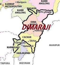
Some Dimasa-Cachar people of northeast India have been demanding a separate state called Dimaraji or "Dimaland" for several decades. It would comprise the Dimasa-inhabited areas, namely Dima Hasao district, parts of Cachar district, parts of Nagaon district, Hojai district and Karbi Anglong district in Assam together with part of Dimapur district in Nagaland.
Proposed boundaries of the state
The proposed state's boundaries would include Dima Hasao, Cachar, parts of Nagaon, Hojai, and Karbi Anglong districts of Assam and part of Dimapur in Nagaland.123
According to the Dima Halam Daogah chief Dilip Nunisa, the proposed Dimaraji would comprise three districts: existing Dima Hasao, Garampani district and Borail.4
References
References
- "Times of India".
- "Economic Times India". The Times Of India. 31 July 2013. Archived from the original on August 3, 2013.
- "India Times". The Times of India. Archived from the original on 2013-07-17.
- SARMA, SARAT (24 September 2011). "DHD not to compromise". The Telegraph, Calcutta. Calcutta, India. Retrieved 7 August 2013.
{{cite news}}: CS1 maint: deprecated archival service (link)