| Dennington | |
|---|---|
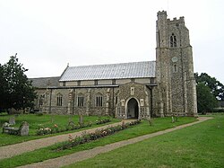 Church of St Mary, Dennington | |
Dennington Location within Suffolk | |
| Area | 13.24 km2 (5.11 sq mi) |
| Population | 578 (2019)1 |
| • Density | 44/km2 (110/sq mi) |
| OS grid reference | TM283634 |
| District | |
| Shire county | |
| Region | |
| Country | England |
| Sovereign state | United Kingdom |
| Post town | WOODBRIDGE |
| Postcode district | IP13 |
| Dialling code | 01728 |
| UK Parliament | |
Dennington is a village and civil parish in the English county of Suffolk. It is 2 miles (3.2 km) north of Framlingham and 15 miles (24 km) north-east of Ipswich in the east of the county. It lies along the A1120 road around 8 miles (13 km) west of the road's junction with the main A12 road in Yoxford.
At the 2011 census Dennington had a population of 578.1 The parish church is dedicated to St Mary.2 The village has a primary school, village hall and pub.34
There is a limited public school bus service linking Dennington to Framlingham and Ipswich.5 The nearest railway station is at Darsham with an hourly service to either Ipswich or Lowestoft.6
Notable residents
- Sir William Phelip, 6th Baron Bardolf (?-1441), Treasurer of the Household, Lord Chamberlain and hero of the Battle Of Agincourt buried in the south chapel of St Mary's Church Dennington.
- Sir Edmund Rous (by 1521 – 1572 or later), landowner, magistrate, Member of Parliament for Great Bedwyn, Dunwich, Dover, and Vice-Treasurer of Ireland.
- William Hughes (?-1600), rector of Dennington and later Bishop of St Asaph from 1573 till his death.
- Lionel Gatford (?-1665), royalist Church of England clergyman and rector of Dennington.
- William Miller (1769 – 1844); leading English publisher.
- Benjamin Philpot (1790-1889); clergyman and Archdeacon of Man from 1832 until 1839.
- Charles Hotham (1806-1855), Lieutenant-Governor and, later, Governor of Victoria, Australia.
- George Burr (1819-1857), first-class cricketer and Anglican priest.
- Peter Hartley (1909-1994); clergyman and Archdeacon of Suffolk from 1970 to 1975.
- General Sir Alfred Dudley Ward (1905-1991), British Army officer who saw distinguished active service during the Second World War and later became Governor of Gibraltar, is buried in the churchyard of St Mary's.
- Ed Sheeran (born 1991), singer–songwriter, resides in Dennington.
References
References
- "Dennington population 2019" (PDF). Retrieved 23 October 2023.
- "Dennington Church". Retrieved 31 January 2013.
- "Dennington School". Archived from the original on 16 April 2013. Retrieved 31 January 2013.
- "Village Website". Archived from the original on April 19, 2013. Retrieved January 31, 2013.
- "118 Bus Timetable" (PDF). Ipswich Buses. Archived from the original (PDF) on 8 October 2020. Retrieved 5 October 2020.
- "Darsham Train Timetable". Retrieved 31 January 2013.